Dorothy – 09/03/05
Bus trips which followed the course of Christchurch’s main rivers were organised by the Christchurch City Council’s Waterways Management Department until February 2005. A commentary and stops at significant areas en route made a trip from the source to the mouth of the Avon River both enjoyable and informative. The University of Canterbury, the Deans houses beside Riccarton Bush, Mona Vale, Millbrook Reserve, the Canterbury Museum, the Arts Centre, the Antigua Boatsheds, the Bridge of Remembrance, the Kate Sheppard Memorial, Victoria Square, Graham Bennett’s steel assemblage from pieces of Twin Towers wreckage, Corser’s Stream, Travis and Bexley Wetlands, and the Avon/Heathcote Estuary were among the places featured on the trip.
Christchurch’s Waterway Enhancement Programme A pamphlet outlines the aims of the programme:
“The Programme is a partnership between the Christchurch City Council and local communities with the aim of enhancing the health of our waterways and restoring their natural processes.
“People throughout Christchurch are working together to:
- protect natural areas
- restore native habitat
- enhance ecosystems for birds fish, lizards and insects
- create green linkages or corridors
- restore waterways for people’s enjoyment and sense of history.”
This is a change from the earlier policy of keeping the banks clear to improve drainage in times of heavy rain. Some deep drains had the sides boarded to prevent the banks from erosion or collapse. The aim now is to widen the area of the stream or drain and have gently sloping banks – which of course requires more land.
The work on the waterways has been undertaken with community support and there has been increased public interest in the city’s waterways.
Avon River trip For the trip we were supplied with an excellent information pack – a detailed itinerary, a handout which gave interesting explanations and historical comments about the sites we were to pass, a map of the Christchurch waterways, swamps and vegetation cover in 1856, a guide to planting on river banks and a pamphlet about Water for Survival, the organisation which received any profit from our tour. My husband and I have lived in Christchurch for many years, but all of this information was of real interest to us, and would be a great asset to people who were newcomers or visitors to Christchurch.
The local Maori called the Avon River Te Kai o te Karoro. The Canterbury Association planned to call it the Shakespeare, but the Deans brothers who settled in Canterbury in 1843 named it the Avon after the stream on their grandparents’ farm in Scotland and their name for the river survived.
The Avon in Riccarton/Fendalton We followed the Avon River from near its source to the Estuary. One of our guides told us that the source of the Avon River varied according to the height of the water table which feeds the springs that are its source. We began with a short walk in the grounds of the Ilam Homestead, past the historic waterwheel which was restored some years ago, over the adjacent bridge, and through the rhododendrons and azaleas to the Ilam Road bridge over the Avon. If you look down into the water there you can see one of the springs which feed the Avon.
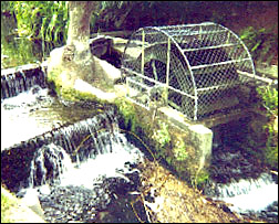 |
| Waterwheel |
From there we drove to the grounds of Riccarton House.
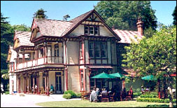 |
| Riccarton House |
We walked along past the Deans’s early cottage and the main homestead and followed the river from Ngahere Street to Kahu Road where the bus was waiting to take us to the Fendalton Road entrance to Mona Vale. Here you can see the result of the present City Council policy of leaving the edges of the river banks untrimmed and allowing grass and sedge to grow there.
Most of us learnt for the first time that it is the Wairarapa Stream that flows under Fendalton Road into Mona Vale. The first stream to join it is the Waimairi Stream and the Avon joins it from the west at the second bridge along the drive.
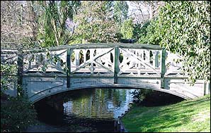 |
| One of the old wooden bridges across the river at Mona Vale Photo source Peter Hunt |
We rejoined the bus at the south end of Mona Vale, near Christchurch Girls’ High School, and drove on to Millbrook Reserve in Helmores Lane. Here we heard about the Carlton Mill which used to be on a site near the reserve, and walked through the reserve to join the bus at the far end.
The Avon in the city The next section of the tour took us past the Museum, the Arts Centre, the Antigua Boatsheds and the site of the Corporation Baths excavated in the Avon in 1877, but of short-lived popularity as they were downstream of the hospital wastes! Next came a length of the river passing many noteworthy sites – the Bridge of Remembrance, the waterwheel, the site of the Kate Sheppard Memorial, the former City Council Chambers, the Worcester St Bridge opened in 1886 and the restored tramway.
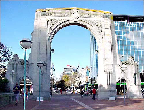 |
| The Bridge of Remembrance over the Avon River in Christchurch (Click here for a larger version) Photo source Robert Hunt |
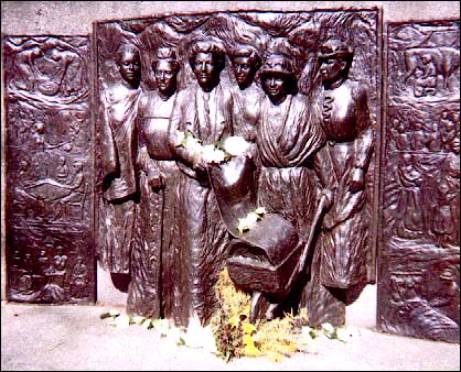 |
| The Kate Sheppard Memorial on the bank of the Avon (Christchurch) Photo source Peter Hunt Click here to view a larger version |
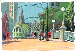
|
|
| Worcester Street Bridge Painting by Bill Moore |
More history followed with Victoria Square’s original role as Market Square, the Bricks where the Deans brother unloaded their chimney bricks as their boat had grounded, and the Edmonds Band Rotunda.
When we reached the Christchurch Central Fire Station we stopped to view sculptor Graham Bennett’s steel assemblage from pieces of Twin Towers wreckage – a quiet and sobering time of reflection.
The Avon east of the city At the Holiday Inn, formerly the Avon Motor Lodge, we stopped for afternoon tea and then drove to Brooker Avenue to view Corser’s Stream. Here we were impressed by the beauty of one of the first areas developed under the Christchurch city Council’s Waterways Enhancement Scheme Programme.
 |
| Corser’s Stream |
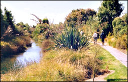
The journey along the expressway gave us the chance to see how the Christchurch City Council’s Waterways and Wetlands team is developing a green corridor between the Avon River and the Travis Wetland and will replace the boarded drain.
We then visited the Travis Wetland which is now a Nature Heritage Park. It was originally part of an estuary and provided the nearby Maori settlement with eels (tuna), fish, wood pigeon (kereru) and food plants such as raupo. Flax was used for making baskets, clothes and roofing. Maori lit fires to flush out the moa, destroying most of the forest. European settlement with farming and drainage and exotic weeds changed the area further. The land was protected by the Christchurch City Council in 1997 and saved from further subdivision and drainage.
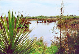 |
| Travis Wetland Photo source Peter Hunt |
We visited the information kiosk which also serves as a viewing place. This proved so interesting that we have returned to the Travis Wetland and explored further. Anyone considering a visit would be wise to get a pamphlet from the City Council. It contains useful information and also urges people not to feed the ducks here as this impacts unfavourably on native species.
To finish our explorations we travelled to the Kibblewhite Reserve at South Brighton and those who still had sufficient energy walked along the bank of the river and viewed the Bexley Wetlands which retain a remnant of estuarine vegetation.
The bus picked up the walkers near the Pleasant Point Yacht Club where the Avon reaches the Avon/Heathcote Estuary.
The trip following the Avon River proved an enriching experience, not only emphasising the importance of the river to the community from early times, the interesting landmarks beside it, the birds, and the plantings on the banks, but also letting us see the changes in the river itself from a small stream to a
sizable river – beautifying Christchurch from its source to the Avon/Heathcote Estuary.