
An Interview with Ken Laing
Dorothy – 23/11/01
It was in the fourth form at Otago Boys’ High School that Ken first became interested in Stewart Island.
|
|
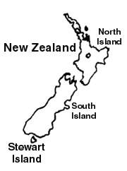
He had as his English teacher Basil Howard who was writing his authoritative volume about Stewart Island, "Rakiura".
Ken still remembers his saying, "If you ever go to Stewart Island don’t put a foot off a marked track or you’ll never be seen again." Ken apparently heeded this advice because he has survived three holidays there and in June 2001 he joined a cruise to the Island.
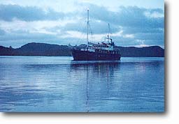
Why a cruise? Ken’s interest in Port Pegasus had been roused by his son’s tales of his experiences when working there on a botanical survey. Ken had never been to this area which is difficult to reach except by a private charter which is very expensive for anyone travelling alone. Then he found that Fiordland Travel runs trips there as the demand arises. This year there was only one six-day trip which took thirty six people with seven crew. They sailed on the Milford Wanderer which also takes trips on Milford Sound and from there to Dusky Sound and Preservation Inlet.
|
|
| Milford Wanderer in Shipbuilders Cove |
Passengers – all New Zealanders – were collected from their motels in Invercargill by the Fiordland Travel bus and taken to Bluff and on to the top of Bluff Hill for a good view of Southland and Stewart Island. Unfortunately the weather conditions were not favourable for seeing a panoramic view.
Once on board they sailed straight to Port Adventure – a three hour trip – bypassing Paterson Inlet and Oban. It was not especially rough by the standards of the seas in the area, but it was certainly not smooth sailing.
Ruapuke Island En route they passed Ruapuke Island, but did not call in. The name Ruapuke means ‘two hills’.
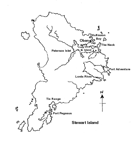
|
|
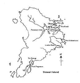
| Map of Stewart Island Click here for a larger version |
It was the headquarters of Tuhawaiki who was the paramount chief of the Ngai Tahu at the time when the Treaty of Waitangi was signed. Some of the European observers who were present at the signing believed that Tuhawaiki knew more about what it meant than most of the Maori and Europeans who were there. He had coastal going ships and when one of them was wrecked south of Timaru he was drowned.
It was on Ruapuke Island that Brother Wohlers, a representative of the North German Missionary Society, set up a mission station in 1844. To quote Basil Howard in ‘Rakiura’, "Wohlers gave up his life to the work, enduring hardship even to the verge of starvation, yet continuing to minister to the spiritual, social and educational needs of the dwellers in the Strait, Maori and European alike." He died there in 1885.
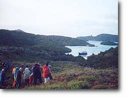
Arrival at Port Adventure Lunch was delayed until 3 pm when the boat reached Port Adventure because conditions while sailing were too rough for serving the meal.
Ken described the first walk on shore. "Straight after the meal everyone was transported to the shore in the Stabicraft – a runabout which was used as a landing craft and could transport about fifteen people. There were no flat landings and we all had to scramble up the steep bank pulling on ferns and trees. On some of our landings they put up a ladder and lashed it to the trees.
"Then we walked around for an hour’s botanical tour in an area where the predominant ground cover was the crown fern. The leader told us that most of the ferns were very palatable to deer so that they were cleaned out except for this variety which they did not like. There was no noticeable track, but the leader was clearly very familiar with the environs.
"It was a very muddy walk and when I looked at my clothes I wondered how I was going to survive five days as I didn’t have five changes of clothing with me. I realised that I should not have worn tramping boots and left my gumboots in the cabin. On my trip to Dusky Sound I was told not to take gumboots and I bought special rubber tramping boots, but here even the crew were wearing gumboots."
The group spent the night in Albion Inlet.
Activities on Day Two The next morning they went down the coast, still within Port Adventure, past Abraham’s Bosom to Oyster Cove. This was so named because oysters were harvested here from 1830. Once they became well-known as a delicacy men would take their boats in at high tide and deliberately allow themselves to be grounded, and then at low tide they would get out and fill up the boat by shovelling oysters on board. They reckoned that was the fastest way to get them on board and when the full tide came back again they would sail off with a load of oysters. By 1872 the beds were closed. They had completely depleted the oysters which never returned even when there were attempts to seed oysters back into the cove.
About sunrise they went to mutton bird islands, just off Shelter Point, through an extremely narrow passage to the opening to Lords River and on down the coast and through the Whale Passage to Port Pegasus.
"On the way," Ken said, "I was fascinated by the hills. Just to the north of Port Pegasus there is the Tin Range where they found tin in the early days, and further west there are two well-known peaks, Gog and Magog.
"The whole coastline is granite cliffs, white in appearance. As we sailed we saw seals on the rocks and also a school of Fiordland crested penguins swimming along and acting just like dolphins. On another occasion we saw yellow-eyed penguins behaving in just the same way.
"We arrived at Port Pegasus around midday."
There had been settlement in this area. Originally prospectors arrived searching for gold which proved rather scarce. In 1888 they found ore which they sent to Otago University for analysis. It proved to be tin but their dreams of making their fortune on mining tin proved illusory. Although a lot of people spent a lot of time exploring for tin they did not do very well. They established a small railway to bring the tin down to the shore for loading on the boats. The party from the boat looked at the ruins of the old hotel there.
On another trip that same afternoon they went up to the Cat Camp. The kakapo on Stewart Island were under terrible threat from the wild cats in the late 1970s and they were to be relocated on vermin-free Codfish Island. However while the work was being done they set up a cat bait and extermination operation to protect the birds while they were trying to collect them. They put 1080 on to fish and left it as bait for the cats.
|
|
| Belltopper Falls |
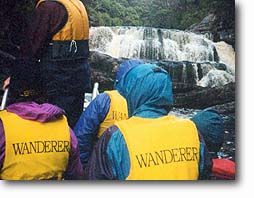
This trip was followed by a visit to the Belltopper Falls, so called because they resembled the hat worn by a Cabinet Minister when he went to visit the falls.
In this area there had been a fish factory with a kerosene refrigerator. It was closed down during World War 1 and reopened only to be destroyed by a landslide. It was later rebuilt in a new location, this time powered using water from the stream above the Belltopper Falls falling on to a Pelton Wheel to generate electricity. The electricity was used for refrigeration and for lighting in the five houses and workshops.
"The water coming from the Falls," Ken commented, "was like the brown water you see in any bushy country – almost the colour of beer.
"At the end of the day some of the party still had spare energy even after three walks and although it was nearly dark got into the twenty kayaks taken on board.
"We spent the night in Port Pegasus in perfectly calm water. I was most impressed by the fact that each night the crew managed to find an anchorage in such calm waters."
Day Three By daylight they were on their way and sailed into the South Arm of Port Pegasus through the narrow Acheron Passage, so named after the ship that did the main survey around the New Zealand coasts. They headed for Shipbuilders Cove.
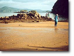
In the afternoon some of the party went ashore at Shipbuilders Cove and climbed a prominent peak called Bald Cone which is just under 1000 feet. They were unlucky enough to be caught in heavy rain on the return trip. Those who decided not to climb Bald Cone were taken out of the harbour to do some fishing off Ernest Island. Some fish were caught, but the fish were not abundant.
They returned to where they were to spend the night at Small Craft Retreat. Next they got into the stabicraft and were taken to a colony of sealions. These were young non-breeding males filling in time until they were old enough to breed. They weighed up to half a ton and were to be treated with respect.
"You don’t get between them and the sea," Ken commented. "It was getting dusk and we were under the bush which made it even darker, so we were very wary as we walked. There was thunder and lightning while we were there. It was the only wet day, but on that day I was really grateful for my gumboots, overtrousers and parka.
"We did see some sealions. Our guide said that you could pick where they usually land as they prefer a sandy place while seals choose a rocky area. However this area was not sandy, so it was surprising to find them there. The guide said that you can pick where they are because of their faeces and their vomit. When they vomit they bring up a lot of stones, possibly because they catch and eat squid with stones in them or because they scoop up the stones by accident. It is interesting that the rock that they vomit is not usually local rock. Their normal breeding grounds are in the Auckland Islands, so the rock may come from there."
On the way to see the Hooker sealions about a dozen fur seals followed the boat cavorting around it in the manner of dolphins.
That night the boat was held by ropes from both sides to the bay as well as anchors as they were not holding very well.
Day Four The day dawned fine and they returned to Shipbuilders Cove and went ashore. To get on land they had climb up ladders fastened by ropes to a tree. They went to where there was an old latrine used by hunters and followed a circular track from there for a botanical walk looking at orchids, lichens and trees, mainly manuka with small white flowers, and dracophyllum varying in size from about 10 cms to 2 or 3 metres, depending on the amount of shelter at the site.
|
|
| Some of the party on the botanical ramble at Shipbuilders Cove, with the Milford Wanderer in the cove |
The manuka on Stewart Island have a differently shaped leaf from the manuka on the South Island so they are thought perhaps to be a different species. There are no kanuka on Stewart Island.
There were bare areas with seemingly nothing growing, and these were called feld fields. The visitors were told not to walk on these areas in case of damaging the tiny growths.
From here there were good views of Gog and Magog and the Hielanman, so called because the shape on top looks like a Highland cap.
After that they sailed north in rather windy and rough conditions, so they turned into the wide estuary of Lords River for an undisturbed afternoon tea.
After dark they reached Paterson Inlet and anchored in Glory Cove.
Day Five Before sunrise they went ashore on Ulva Island.
|
|
| Ulva Island in Paterson Inlet |
There was a good track partly formed around the island. The island was declared a Scenic Reserve in the 1920s and recently it was cleared of introduced rats by the Department of Conservation and declared a DOC Open Sanctuary.
As a result while in other areas there had been few birds, on Ulva Island there was abundant bird life. Red and yellow fronted parakeets were easily heard but not so easily seen high up in the canopy. Forest parrots/kaka came down to see the visitors, and there were lots of tomtits/ngirungiru, fantails/piwakawaka, bellbirds/korimako and tuis.
The guide showed the party the nests of parakeets and kaka. They hollow out the side of a tree and dig down to form a nest. They have to use their beaks to help them clamber out. The parakeets strip the bark off the rimu and the totara to get at the juice. The party were also shown a tree with lightning strike. It had a dead strip where the lightning had struck and burnt the side of the tree.
Where boats are landed there is a marker with rat bait to catch any rat which should come ashore.
|
|
| Some of the party view the hardware left at the Norwegian Whaling Base |
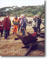
While in Halfmoon Bay the party went to Kaipipi where the Norwegian whalers had their base and saw the foundations of old buildings, much ironware, and a large boiler. A fairly steep climb up a hill led to the area where the whalers had built their huts.
|
|
| Kayaking in Paterson Inlet |
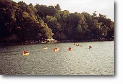
After those who wished had gone out in the kayaks the party settled down for the night on the boat in Glory Cove.
Day 6 The last day began with a visit before sunrise to the mussel and salmon farms at Little Glory and then to Golden Bay and Thule. From there they walked over the hill to Oban looking at the museum, the Department of Conservation’s Visitors’ Centre or the shops. They had lunch at Horseshoe Bay and from there the boat returned to Bluff.
Passengers received a certificate stating that they had undertaken the trip and a very informative book about Stewart Island, the geology, the wild life, the trees and plants and the history.
"The people were easy to get on with and the crew were very helpful and friendly," Ken said. "Allowance was made for anyone who was slow or disabled in any way. I found it a really good trip."
Photos were supplied by Ken Laing
