Dorothy – 19/07/02
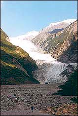
Franz Josef Glacier and Fox Glacier attract thousands of visitors each year
because they can be viewed easily by travelling only a short distance from
the main highway along the West Coast of New Zealand. Franz Josef Glacier
can be viewed by travelling 5km south of the village to the carpark and walking
2km on a fairly rough track to the face of the glacier.
|
|
| Franz Josef Glacier today |
Movement of the glacier The studies of geologists have shown that both Franz Josef and Fox Glaciers
have receded over 3km since the eighteenth century, and 2km since Julius von Haast explored the Franz Josef Glacier in 1865 and named it after the
emperor of Austria, his native country.
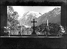
St James Anglican church, has a clear glass window over its altar. When the church was built in 1931 the window afforded a view of the glacier.
|
|
| Glacier view from St James Anglican church in 1945 Photo source Nina Proctor |
This scene was shown on a Peace Stamp in 1946. By 1953 the glacier had retreated and was no longer visible, but the view is still impressive.
Since 1865 the glacier has at times made small advances but overall it has
retreated markedly. There was a period of advance between 1985 and 2000 but it now seems to be retreating once again.
Franz Josef Visitor Centre and Department of Conservation (DOC) Office Seeing the glacier, for most visitors, is the main reason for stopping at
Franz Josef, but to get full value from your time there it is wise to start
with a visit to the Visitor Centre and DOC office which are in the one attractive building. Here you can find pamphlets giving information about
walks in the area, and also view excellent displays. You can watch a documentary about the South Westland World Heritage Area. Displays focus
on the Alpine Fault, the geology of the area, erosion and the weathering process, the braided channels of the Waiho River which flows out at the foot of the glacier, and the receding of the glacier since 1865 when Julius
von Haast became the first European to explore the glacier. There are displays relating to the native birds in the area, including the white heron which nests at Okarito Lagoon 18km north of Franz Josef.
Project Crimson When I last visited there one outstanding display dealt with Project Crimson – a scheme begun in 1990 to counter the threat to pohutukawa and rata trees from possums. Project Crimson is a charitable trust which was sponsored by Carter Holt Harvey and DOC. Meridian took over as major sponsor of Project Crimson
on 2 October 2006.
Pohutukawa numbers began to reduce in
1990
and by 1996 rata was also under threat. Each night throughout New Zealand
possums eat 20,000 tonnes of vegetable matter, and the young tips of pohutukawa and rata flowers seem to be a tempting delicacy for them. Schools and communities are being encouraged to put effort into plantings
and care of these mainly red flowering shrubs.
Relief model of the mountainous surrounding area A relief model of the surrounding area shows the Franz Josef and Fox Glaciers, the Tasman Glacier below Mount Cook and Mount Tasman, the Okarito
Lagoon and to the south the Copland Valley and Pass and the Welcome Flat Hot Springs.
The road between Franz Josef and Fox Glaciers represented a challenge to the builders as it crosses three spurs. The modern sealed highway winds its way through the bush clad hills to take you the 24km between the two settlements.
Rainfall Glass tubes showed the annual rainfall in different places – Auckland, Wellington, Christchurch, Dunedin, Sydney, Perth, Tokyo, Munich, London, Edinburgh, Los Angeles and New York. The highest rainfall among these was
Tokyo with around 1500 mm. For Franz Josef the annual average recorded was
just under 5000 mm.
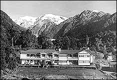
Glacier Hotel For many years the best place to stay was the Glacier Hotel, Franz Josef,
but sadly it was burnt down on 15 August 1954.
|
|
|
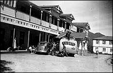
| Glacier Hotel, Franz Josef Photo source Nina Proctor | The bus outside the Glacier Hotel in the early 1940s Photo source Jean Dick |
visited Franz Josef in the early 1940s and remembers the buzz of activity
when the bus arrived at the hotel.
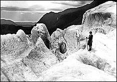
She also recalls vividly the most exciting event on her holiday when she was taken up on the ice by the well-known climber and photographer Bill Fraser.
After testing her fitness by a demanding walk he decided that she would cope and took her to be equipped with clinkered boots and an alpenstock. It was her first experience at tramping on ice and she treasures the photograph which he took.
|
|
| Jean Maclachlan on Franz Josef glacier Photo source Jean Dick Photographer Bill Fraser |
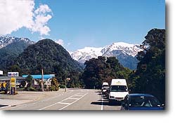
Franz Josef village The village now offers a variety of accommodation, shops and eating places.
As it is a long way from main centres groceries are fairly expensive. We were watching our holiday budget and ate an inexpensive but satisfying and
well cooked meal in a friendly atmosphere at the Cheeky Kea Cafe.
|
|
| Franz Josef’s main street |
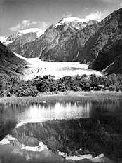
Walks Peter’s Pool After you have been to the face of the glacier you may want to do other walks. On your way back you could follow the turn off to Peter’s Pool, five minutes off the track. The pool is a kettle lake – which means that
it was formed by the melting of a block of ice. It can offer impressive reflections on a fine day.
|
|
| Reflections in Peter’s Pool in 1945 Photo source Nina Proctor |
You may choose to continue on the circular track which takes about an hour
and leads back to the valley road.
Sentinel Rock This rock offers an interesting ten minute climb with an attractive view of
the glacier, but be careful near the top where it is very steep.
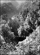
Callery Gorge The Callery River is a tributary of the Waiho River. This inhospitable area was the source of alluvial gold and attracted miners in the early years. The Terrace Walk takes you to the suspension bridge at the end of
the gorge. A visitor in 1906 wrote of the desolation of the scene and the
damage done to this beautiful area by the miners, but now the regrowth of
kamahi has covered most of the relics of the mining.
|
|
| Swing bridge at Callery Gorge in 1945 Photo source Nina Proctor |
Short drive to Lake Mapourika This is the largest lake in South Westland (11 square kilometres). It is
worth driving the nine kilometres north of the village on SH6 to picnic at
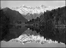
the lake. It is stocked with trout and quinnat salmon. Its reflections are less well-known but are almost as beautiful as those in Lake Matheson.
|
|
| Mt Tasman and Mt Cook reflected in Lake Mapourika Photo source Nina Proctor |
A tourists’ Mecca A visit to the West Coast Glaciers is a unique experience and the journey
to get there takes you through beautiful and interesting country. Visitors
were drawn there when it involved a long journey and difficult river crossings,
but now sealed roads and well-designed bridges make travelling comfortable
and easy. Do take any opportunity to visit this area of majestic beauty.

