More on South Island travel Dorothy – 10/05/02
On the last leg of our trip we travelled through the magnificent scenery of the Haast Pass to the township of Haast. Equally beautiful but different scenery lies ahead – stretches of unspoiled coast, native bush, snowy mountains, lakes, streams and native wildlife.
Haast Visitor Centre Before you leave the Haast area be sure to visit the Haast Visitor Centre. It was opened in December 1991, and now has over 110,000 people passing through it each year. It is open 9.00 am – 6.00 pm from 1 November to 31 March (though it is closed on Christmas Day) and 9.00 am – 12.00 and 12.30 – 4.30 from 1 April to 30 October.
Clear and effective displays highlight the natural and human history of the South Westland area and show why it is part of Te Wahipounamu – South Westland World Heritage Area. You can watch the twenty minute film Edge of Wilderness which introduces you to the majestic beauty and special features of South Westland.
Information The staff at the centre can give you information about walks and viewing points and you can buy brochures, maps, hut tickets and hut passes. Books, posters and postcards can also be purchased at the Centre.
Over the Haast River Bridge and north The bridge over the Haast River is long – 723.4 m (2417ft 3.5 in). It is 3.7 metres wide (12 ft) and has two passing bays. It is the longest single lane bridge in the country. It is built 3 metres (9ft 10 in) above the highest known flood level and designed to withstand flows of over 11.000 cubic metres a second. It was completed in 1964.
If you have time for a break you could stop at the carpark at the north end of the bridge and follow a fifteen minute loop walk in coastal forest with some large beech trees.
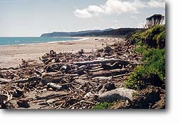
Ship Creek Back in the car the next section takes you through undulating country across sand dunes covered in forest and swampy areas with glimpses of the sea. You may wish to pause at the Tauperikaka River. The small river acquired another name – Ship Creek, after part of a ship was washed up on the beach. This was believed to be part of the Schomberg which was wrecked off Cape Otway, Victoria, in 1854. The Schomberg was a 2600-ton clipper on her maiden voyage – the largest wooden ship ever launched from a British yard. You can read a full version of its story. Link to http://www.eraoftheclipperships.com/page57.html A few small pieces of the wreckage can be seen in The West Coast Historical Museum in Hokitika.
On to Knights Point From Ship Creek the road rises and falls as it crosses a number of creeks and ridges. Breccia Creek was the point at which the gangs working from the north and the south met in June 1965. The road then passes through Epitaph Cutting, 183 metres (600 feet) above sea level, the highest point on the road between Haast Pass and Fox Glacier, before dipping down to cross another creek and climbing to Knights Point 137 metres (450 feet) above sea level.
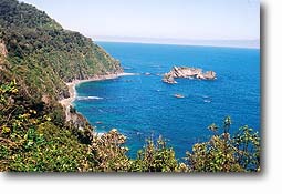 |
| View from Knights Point |
Here there is a plaque which commemorates the official opening of the through route linking the road to the north with the road south from the glaciers. It was opened by the Prime Minister, the Rt. Hon. K. J. Holyoake, in November 1965. At last it was possible to travel by road from Otago direct to Westland. Within hours of the official opening the road was closed again by a landslide. People wondered if the gods resented the opening up of this previously secluded area.
Knights Point is one of those areas where almost all photographers stop, get out their cameras and try to capture the spectacular view out over the Tasman Sea and along the coast. The bush in this area grows in luxuriant profusion, even on the high rocks off the coast. If you are lucky enough to visit in the summer when the rata is flowering the deep green vegetation is brightened by patches of rich red.
Lake Moeraki This little bush-clad lake is close to the road and it is well worth stopping here just to appreciate the beauty of the scene. In calm weather the trees and the mountains are reflected in the water. It is a popular place for trout and salmon fishing. Keep a lookout for the kotuku, (the white heron), a rare bird sometimes seen on these southern coasts. Bird watchers also visit to see the crested grebes (puteketeke) which nest here.
A walk from a lane a short distance north of the Moeraki Bridge leads to Munro Beach. Allow about half an hour to reach the beach. Don’t take a dog as this beach is the home of penguins.
The Cattle Track In the 1870s this track was built so that farmers could drive cattle to the saleyards further north at Whataroa. It continued to be used until the road to Otago opened in 1960. It starts just north of the Windbag Stream and trampers can use huts on the track and have a two day trip to a point near the Waita River mouth. Those wanting a short walk can take part of the gently graded track and return along the same way.
Lake Paringa
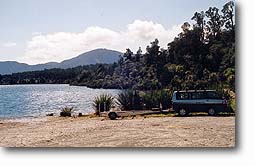 |
| Picnic ground at Lake Paringa |
24 km (15 miles) from Knight’s Point you reach Lake Paringa. Until the mid 1950s Paringa was almost the end of the road south along the West Coast.
By the Paringa River there is a tablet marking the point at which Thomas Brunner turned back to the north when exploring the West Coast. He had injured his foot and was forced to rest for healing.
An informative notice board at the Lake Paringa picnic ground comments on trees, bird life, bats and the nature of the country.
“The renowned beech gap” This phrase on the notice board means that there are no southern beech trees, nothofagus, from Paringa to the Taramakau River. The silver beech is commonest from the sea shore up to about 900 metres (2950 feet). It is worth walking along the fifteen minute circuit of the Jamie Creek Walkway as it takes you through kahikatea, rimu and silver beech trees, the last you will see until you travel north of the Taramakau River.
Birds in the area Birdwatchers will appreciate the information about birds on Lake Paringa. The crested grebe breeds in floating nests on the lake. Scaups fly low over the water and dive up to two metres. Shovelers are found here – the fastest flying waterbirds in New Zealand. They feed on freshwater fish, insects and the seeds of fringing plants. Other water birds include grey and mallard ducks, black swans, black shags.
The fern bird, Kaka and the yellow crowned parakeet, kakariki, are found in the area. The bush falcon, karearea, is found particularly in the Moeraki Valley and Windbag Valley. It hunts smaller birds, even pigeons. Occasionally the spotless crake has also been seen.
Mouse sized bats which nest in the hollow trunks of trees fly around the lake from dusk to dawn.
Brown trout and quinnat salmon may be caught in the lake in season.
The Alpine Fault Paringa is close to the Alpine Fault. Fish Hill which is hard greywacke was not moved when the glacier pushed over it. This is how Lake Paringa developed its horseshoe shape.
Staying overnight Having absorbed all this information on the notice board you will read that camping is allowed, and that toilets and some water is provided. You may choose to stop for the night, but you are warned to use your sandfly repellent. You may prefer to stay at the Lake Paringa Heritage Lodge.
Bruce Bay
 |
| Bruce Bay |
After crossing the beautiful Mahitahi River you drive through an impressive avenue of mixed rimu and podocarps and ferns and tree ferns. Some 24 km (15 miles) from Paringa the road reaches the coast at beautiful Bruce Bay where there is a small settlement. When we stopped there on a beautiful sunny day it was hard to believe that it had once been the site of a mushroom town. This town sprouted almost overnight after Albert Hunt, who had started a greenstone rush two years earlier in 1864, arrived in Hokitika with a hundredweight of gold, and was granted a claim south of Bruce Bay. About 2000 men gathered at Bruce Bay and tried to force Hunt at gunpoint to lead them to the new goldfield, and when he disappeared in their frustration they looted and tore down the makeshift buildings which hopeful traders had built along the shore.
The Karangarua River Bridge 1939 The road now passes through native bush – mainly rimu and kahikatea – and crosses the Karangarua River. Geoffrey Thornton, in his book Bridging the Gap, describes it as “a large but well-proportioned bridge …. the epitome of the Public Works Department’s suspension bridge design … The plate girder stiffening truss is the longest single suspension span still in use in New Zealand.” The bridge has a span of 130 metres (426 ft) and tall braced steel towers.
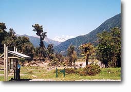
Copland Pass Track From this point on cattle are to be seen grazing on the areas where the trees were felled for milling. Soon after crossing the Karangarua River you come to the starting point for the Copland Pass Track.
 |
| The starting point for the Copland Pass Track |
There is a memorial to Charles Edward Douglas 1840-1916, who explored and surveyed the area. Also recorded is the fact that in 1903 three women crossed the Copland Pass – the first women to complete the crossing.
Many trampers walk as far as Welcome Flat which takes five to six hours. There is a bridge for crossing all the bigger creeks. The hot pools attract a lot of trampers so there is a large hut there. Further on the terrain changes and even in summer there may be ice near the pass and there can be sudden changes in the weather. The crossing of the pass is usually made from the Hermitage side, and it is suitable only for experienced mountaineers.
A short drive then brings you to Fox Glacier, and scenic wonders which will be described in the next article in this series.