Catherine Richards – 02/05/08
North Canterbury’s impressive array of food and wine experiences are about to receive a much higher profile thanks to the launch of a new regional food and wine trail.
The trail will showcase North Canterbury’s culinary talents and highlight the region’s distinctive rural flavours and personalities.
Forty businesses from Waimakariri, Hurunui and Kaikoura are on the North Canterbury Food and Wine Trail including wineries, fruit and vegetable growers, artisan producers, accommodation providers, cafes and restaurants.
“North Canterbury offers a fantastic variety of authentic gastronomic experiences that visitors from New Zealand and around the world will savour,” says Catherine Richards, Marketing Executive for Visit Waimakariri.
The trail, initiated by Enterprise North Canterbury, is the culmination of a marketing collaboration between Visit Waimakariri, Alpine Pacific Tourism and the Kaikoura District Council, who are committed to promoting the region’s distinct food and wine flavours.
 |
 |
| Alpine Pacific Tourism Image Copyright Photo source: Alpine Pacific Tourism |
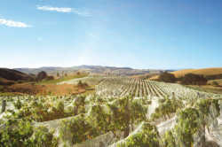
Looking across one of North Canterbury’s many vineyards Photo source: Alpine Pacific Tourism Click here to view a larger version |
Craig Wilson of the ‘New Zealand Food and Wine Marketing Network’ welcomes the trail’s development.
“This initiative will move the region beyond just good food and wine to a new level, where the importance of local products, place and personalities becomes integral to the overall experience.
“The slow food movement is growing internationally and New Zealand is well positioned to take advantage of this trend. Cantabrians have a delicious asset on their doorstep, providing the perfect complement for a leisurely drive or overnight experience in the country,” says Craig Wilson.
A guide and map have been created to promote the trail and to encourage people to explore the region. Copies of the guide will be available from local businesses and
i-Site Visitor Centres or contact info@visitwaimakariri.co.nz for a copy.
Tourism New Zealand Chief Executive George Hickton officially launched the North Canterbury Food and Wine Trail at a function in Waipara on April 16.
 |
| Heather Miller, Enterprise North Canterbury, Ann Paterson, Kaikoura District Council, George Hickton, CEO Tourism New Zealand, Scott Pearson, Alpine Pacific Tourism, Catherine Richards, Visit Waimakariri. Photo source: Alpine Pacific Tourism Click here to view a larger version |
The location of the districts
The North Canterbury region, which includes the Waimakariri and Hurunui Districts, is bordered by the Southern Alps on the west and the Pacific Ocean on the east.
The Waimakariri District lies to the north of the Waimakariri River, extending from the Puketeraki Range in the west to Pegasus Bay in the east. The district has fertile land and highly productive rolling downs.
The western landscape is dominated by Mt Oxford, Mt Richardson, Mt Thomas and Mt Grey. The Waimakariri District has an approximate total land area of 225,000 hectares and 13 kilometres of sandy beaches.
The main urban areas are Oxford, Rangiora, Kaiapoi and Woodend.
The Hurunui District begins at the town of Leithfield, and extends to the Conway River south of the Kaikoura Peninsula. The main urban areas are Amberley, Cheviot, Culverden and Hanmer Springs.
The Hurunui District is about four times the size of the Waimakariri District. Its approximate total land area is 864,640 hectares.
The Kaikoura District includes the Oaro Hills (including the coastal strip from Haumuri Bluffs [earlier known as Amuri Bluff] to Peketa), the Kaikoura Lowlands (including the Peninsula), the Seaward Kaikoura Range, the Inland Clarence Valley, the Inland Kaikoura Range, Rakautara, Clarence and the Kekerengu Valley.
The mountains and coastal areas have outstanding scenic value.
The main urban area is Kaikoura.
 |
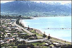
| Kaikoura Township Looking North Photo source : Joe Levy |
The town has grown rapidly since the increasingly popular Whale Watch trips by boat or helicopter have attracted thousands of tourists annually.