– Dorothy – 21/11/97
Travelling along State Highway 1 between Christchurch and Picton State Highway 1 carries a lot of traffic at any time, but during the summer and especially in the holiday period it is a very busy road. Our family have travelled it many times en route from Christchurch to Picton, Nelson or the Nelson Lakes National Park. That part of the country is so popular in summer that there is heavy traffic – cars packed to the roof with luggage, cars pulling trailers full of camping gear, caravans or boats, motorhomes, and heavy trucks transporting goods to and from the ferry. This means that the driver can become fed up with following the same vehicle kilometre after kilometre, especially over the Hundalee Hills and along the Kaikoura coast.
Our other problem when the children were small was that they grew tired of being in the car and asked endlessly, “When are we going to get to Nelson?”
The solution for all frayed nerves in our experience was to stop and go for a walk. With luck the little ones spent so much energy that they fell asleep soon after and we could drive on in peace.
Where are these walks? Domains and rest areas all along the road provide a break, but our two favourite walks are on the Kaikoura coast, one south of Kaikoura, one to the north. Neither involves leaving the main road. Both take a short time.
The Omihi Scenic Reserve Walk If you are travelling north watch for the Ocean View Restaurant and Motels, north of Oaro, travel 1.3 kms and pull off on the left of the road. If the parking there is full there are parks in the picnic area on the other side of the road.
If you are travelling south note the Goose Bay bridge and then travel one kilometre south watching for a not very conspicuous sign in a clearing on your right.
Cross the railway carefully at the sign marking the beginning of the walk.
This is an undemanding walk on a good track, taking twenty minutes each way. It is fairly dry all the year round, and light footwear is adequate unless there has been heavy rain. It begins at an easy gradient and gradually climbs to a lookout giving excellent views north and south along the coast. The walk is sheltered and on a hot day it is pleasantly cool under the trees.
Trees and plants Our pleasure in the walk was increased when we went with Joe Levy, former Canterbury Conservator of Forests. He pointed out trees and plants that would have escaped our notice.
The shady nature of the walk meant that we could not take photographs in the bush, so a description will have to suffice. It is set among coastal hardwood forest. It starts among kawakawa, the peppertree, which Maori value for medicinal purposes. The canopy of foliage comes from the whiteywood, and the ngaio. On the side of the track are small hen and chicken ferns.
Tree fuchsias can be recognised by their orange-tinged, peeling bark. They grow to an interesting shape. The five finger, popular in home gardens as a smallish tree, here grows over twenty feet tall. Ake ake have an orange red bark with a stringy texture.
On the left note a tall ribbonwood with a dark trunk and further along a red matipo.
Towards the top of the track watch for maidenhair fern, golden ake ake, (which you may recognise as a popular hedge plant), a native myrtle with a nobbly trunk, a pigeonwood with orange berries in season, hebes, and a large leaved Broadleaf. At your feet you may see Dianella, a low growing plant which has white flowers with three petals. It is sometimes called blue berry as it has rather lovely blue berries in autumn.
Birds As you walk you have a good chance of seeing some native birds – brown creepers, bellbirds, grey warblers and fantails.
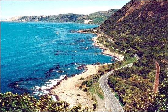 |
| The view south looking toward the Amuri Bluff. The coastal strip in the foreground was a Ngai Tahu village site in the nineteenth century and earlier. |
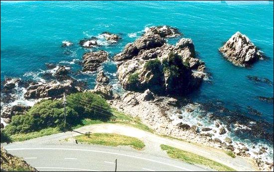 |
| The view of the gull-nesting reserve to the east. |
View from the top From the top you have a clear view of the coast to the north and the south and can look down on the seals on the rocks below. This rocky area area is a reserve for the benefit of red-billed gulls which nest there in spring and summer.
The downhill walk You have the choice of returning the way you came or going down the other side of the hill by a more open zig-zag track which follows the power lines and descends more sharply through bracken and grass. This comes out near the end of the railway tunnel under the hill, at a point a kilometre by road from the starting point.
You may wish to do the walk from north to south, but it is much more difficult to find the access point as it is unobtrusive. It is close to the end of the tunnel beside Goose Bay bridge.
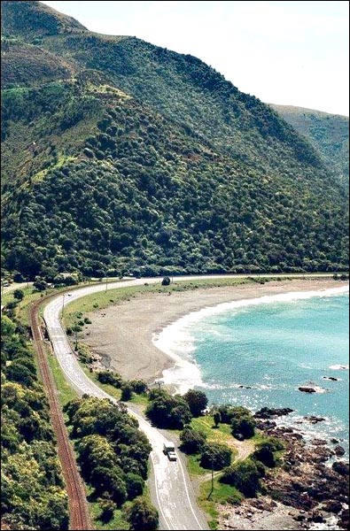 |
| Looking north over Goose Bay |
North of Kaikoura Travelling north you will very likely stop to look at the seals at Ohau Point where there is a pull-off area of tar seal on your right just past Half Moon Bay. A short distance further north as the road descends to the coast a signpost clearly indicates the walk to the Ohau Falls.
Travelling south after crossing the Clarence River watch for the Black Miller Stream. Three kilometres south of this there is a signpost and an opening parking area both side of the road.
This fifteen minute walk begins underneath the railway line and leads you on a good track through the trees – again coastal hardwood forest – to a small waterfall which is a cool oasis during travel on a hot summer day.
Travel on – a refreshed and safer driver.

