Dorothy – 3/12/99
The journey from Christchurch to Arthur’s Pass is only 154 km (95 miles) but to appreciate what lies along this road much more time is needed than that distance would suggest.
The first road from Christchurch to the West Coast through Arthur’s Pass was finished in 1865. It was built to satisfy the demand for an improved route to the goldfields on the West Coast. The firm of Cobb and Co. established a coach service in 1866.
Finding Highway 73 – travelling to Springfield The route to the Pass today is Highway 73 – a sealed road all the way. The simplest way to get on to it is to find Riccarton Road in Christchurch and towards the end of the Upper Riccarton shopping centre at Church Corner turn half right into Yaldhurst Road, the main road to the West Coast.
For the first sixty kilometres (38 miles) of the journey you travel on a highway climbing only gradually until you reach Springfield. On a clear day you have a view of the mountains ahead, particularly impressive in the mornings when the sun is on the eastern slopes.
Just past Yaldhurst you have a choice of route, and can turn half right into the Old Coast Road which was used by the Cobb and Co coaches or follow highway 73. The Old Coast Road takes you through farm land and affords an occasional glimpse of the Waimakariri River to the right. It links with highway 73 at Sheffield. Highway 73 takes you through Kirwee, and the pleasant country town of Darfield.
Kirwee At Kirwee you will notice an obelisk which honours the memory of Colonel Brett, an early settler in the area. He had served in the British army in India and called his farm Kirwee after an Indian village. He realised that the success of farming on the Canterbury Plains was threatened by the droughts common in summer and organised a network of water races using water from the Kowai River for farms in Courtenay, Malvern, Hororata and Kirwee.
Memorial to Rewi Alley Take time in Springfield to visit the memorial to Rewi Alley. He was born in Springfield in 1897 but after fighting in the trenches in France in World War I and farming for six years in Taranaki he went far from his rural Canterbury birthplace to work in China. He is probably better known in China than in New Zealand for his selfless work to help the Chinese people. He worked as a fireman, and a factory inspector, and during the war between China and Japan to help the war effort he travelled widely to set up cooperative work groups in the Gung Ho cooperative movement. He founded a school in a town on the edge of the Gobi Desert to train young Chinese in technical and academic skills and worked as its principal for six years. He moved to Beijing in 1852 and lived there until his death in 1997. Once the new reform policies were introduced in the late eighties he worked again successfully for the cooperative movement, established a second school and a museum.
For these and other services to the country he was highly honoured by the Chinese leaders. After the end of the Cold War his work became better known in New Zealand and in 1985 the New Zealand Government awarded him the Queen’s Service Order.
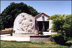 |
| The memorial to Rewi Alley at Springfield – the sculpture with the information centre behind it |
The monument is a poured concrete bas-relief statue showing him with two Chinese children and a lamb. It was a gift to the community of a Chinese couple, Deng Bang Zheng who designed it and Lu Bo, his wife, who sculpted it. They spent several months in Springfield working on this project. It is set in a small park and behind it is a shelter with panels depicting significant stages in Rewi Alley’s life. As you enter a recorded account of his life plays automatically telling the story of his work in English and in Chinese.
Entering the mountains from Springfield From Springfield the road begins to climb steadily at first and then steeply up to Porters Pass 945.5 metres (3100 feet) above sea level, 18 km (11 miles) from Springfield). This is the highest point on the road. If you are travelling in the depth of winter it is wise to find out before leaving on your trip whether Porters Pass and Arthur’s Pass are open as they are occasionally closed by snow.
Lake Lyndon The road from the top of the pass drops down to Lake Lyndon, ? metres (2,770 feet) above sea level. The lake is occasionally frozen over in winter sufficiently for it to be used for skating. Years ago blocks of ice used to be cut from the lake and transported to Christchurch to be used for refrigeration. This unpopulated area is transformed after a snowfall into a crowded mecca for families seeking fun in the snow, tobogganing on the slopes beside the road, steep enough to provide fun, but gentle enough to be suitable for children.
Castle Hill After a sharp descent to the Porter River Bridge you pass the road to Porter Heights skifield and approach Castle Hill, easily recognisable by the huge rock formations on the hillside. A signpost on the left shows the start of the track. There is a small car park.
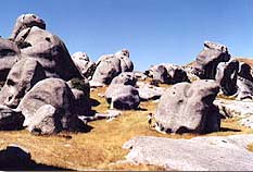 |
| Huge and weirdly shaped rocks make the spectator feel insignificant |
You will want to allow time to explore the rocks as wandering among these huge limestone formations is an awe-inspiring experience. Keep walking past the smaller rocks near the road until you reach the more majestic formations further on. There are all sorts of shapes as though a giant sculptor has been at work creating arches and weird prehistoric animals so large that the spectator feels insignificant.
Cave Stream Reserve On the right hand side of the road further on is the Cave Stream Reserve which is karst topography – country with sinkholes and caves. The Cave Stream flows underground for some 360 metres. Do not attempt to go through this tunnel without a guide. It can be dangerous after rain and people have lost their lives attempting to go through when the streams are rising. Even if you venture only a short distance in warm dry weather be prepared for it to be very cold and take a reliable torch.
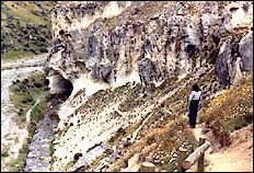 |
| Cave Stream Reserve |
Castle Hill Resort In the coaching days, Castle Hill was promoted as a health and holiday resort, and the hostel, built in 1871 of local white stone, offered “first class accommodation”. A short distance further on the remains of the old hostel – some foundations and a chimney – can be found on the right. The area is still popular for winter sports, rock climbing, and summer holidays and a number of new houses have been built in the Castle Hill Village.
Descend into the gorge to cross the Broken River Bridge and imagine what a taxing trip this must have been for the horses pulling the Cobb & Co. coaches.
Craigieburn Forest Park Craigieburn Forest Park is the next point of interest. There are two points of entry on the left of the road. It offers good walking tracks, either a short walk to break your journey, or a full day’s tramp. The second entrance beside the Craigieburn Stream offers a handy picnic place close to the road. Remember to take your insect repellent!
Four skifields operate in this area in winter – Mount Cheeseman, Broken River, Craigieburn and Mt Olympus.
The lakes The road descends sharply at the Craigieburn Cut and then runs beside the Craigieburn Stream and passes Lake Pearson and Lake Grasmere – both well-known trout fishing spots. The fishing season runs from the first full weekend in November to the end of April. When you buy your fishing licence you will be given all information about restrictions on fishing there.
Lake Pearson is the larger lake, shaped like a hour glass. On still days it mirrors the surrounding mountains, but on other days the wind sweeps across it whipping up sizable white capped waves. There are places to picnic and launch a small boat.
The Bealey and the moa The next landmark is the little village of Cass, originally a railway settlement at the terminus of the railway to the west. Some 16 km (9 miles) further on is the Bealey settlement. Holiday houses have long clung to the Bealey Spur, but the casual traveller can find good accommodation and restaurant and bar service at the Bealey Hotel a little further along on the right.
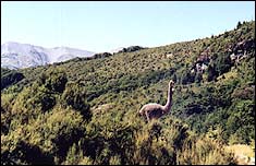 |
| The moa at the Bealey |
As you drive into the hotel car park note the moa, the large bird depicted on your right, to remind us of the story of the group including Paddy Freaney, the owner of the hotel, who claimed a few years ago to have found a surviving moa and produced a photograph to substantiate their claim.
The last lap to the Pass Leaving the Bealey you will shortly enter Arthur’s Pass National Park. Soon you cross the Waimakariri River bridge where on a clear day there is a magnificent view of mountains at the head of the valley. There is a sheltered picnic and camping place at the near end of the bridge on your left. The weather is often clear here when rain is falling at Arthur’s Pass Village.
Crossing the wide bed of the Waimakariri River was a major hurdle for travellers before the bridge was built, and travellers sometimes stayed until the river level fell at Klondyke Corner at the north end of the bridge or at the Bealey Glacier Hotel south of the river. Several hotels were built at the site but destroyed by fire. Towards the end of the nineteenth century the proprietor, J. O’Malley, took parties of tourists to the head of the Waimakariri Valley to view the glaciers. This was the first tourist venture in the area.
The road then runs through beautiful bush beside the Bealey River until you come into the alpine village of Arthur’s Pass – 152 km (95 miles) from Christchurch.
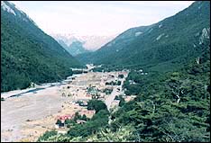 |
| Arthur’s Pass village – the destination |