Dorothy – 2/6/00
A scenic journey to a beautiful area, now 40 minutes on a sealed road…..
Travel from Queenstown to Glenorchy Visitors to Queenstown now drive to Glenorchy on a sealed road in 40 minutes, but for many years after the first settlement transport was only by the steamer, TSS Earnslaw, or by a pack track.
What did the guidebooks tell nineteenth century travellers? "Tours and New Zealand Excursions 1908 Tourist Guide to the Lakes, Mountains and Fiords of Otago and Southland and Stewart Island” Printed by the Government Printer tells readers that to reach Glenorchy they will have to travel 35 miles by steamer, stopping at Kinloch on the way. The cost of the trip is given as 15s and 11s return.
The Guide gives a lyrical description of the views and recommends that the trip be taken in late summer. It states that there are three hotels and gives details of local tramps and climbs.
New Zealand Index H Wise and Co (N.Z.) Ltd 1925 still states in 1925 that reaching Glenorchy meant a three hour trip in a steamer with sailings on Monday, Wednesday and Friday in summer and Tuesday and Friday in winter. Tourists are recommended to stay a week rather than returning on the same day. There is a motor service to Paradise by this date.
The New Zealand Guide A Wise Publication 1962 tells readers that a road to Glenorchy is being constructed. A regular motor service connects Glenorchy with Paradise twelve miles away.
Road construction
For some years there was a gravel road from Queenstown to Closeburn Station and then a dozed track as far as Bob’s Cove.
From the Glenorchy end the Smith family had constructed a road as far as Cerighton Station, and extended it about 1957 through Bennetts Bluff and almost to White Point.
In 1957 a contract was let to link the two sections and build a road from Closeburn Station to White Point. Ian Robinson who worked on this contract described it as “a dangerous job involving complicated rock work and explosives on slip-prone country.” A serious slip destroyed part of the road one day before the completion of the contract. A temporary wooden structure was built after the slip and later a concrete cantilever bridge.
Travel by Road The road to Glenorchy was opened in 1962 but remained unsealed until December 1998.
Along the road This is sheep farming country and occasionally the traveller is delayed by a typical high country ‘traffic jam’.
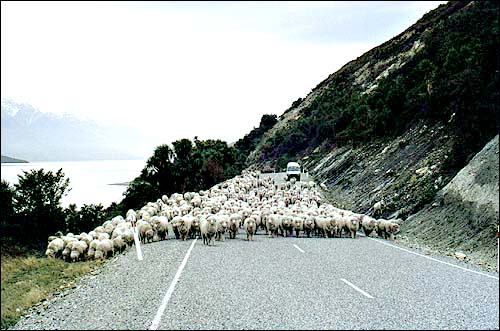 |
| Typical high country ‘traffic jam’ Click here for a larger version |
Walks along the road Walks have been developed using parts of the old pack track, and as you drive along the road there are signposts to tempt the walker to stop and explore.
Ten kilometres from Queenstown at the Twelve Mile Creek bridge is the start of the 2-4 hour Twelve Mile Loop Track. On this walk you can see the evidence of gold mining and gain a view of Lake Dispute. An alternative is the walk to Lake Dispute – 1.5 hours return. This can be linked to the Twelve Mile Loop Track. The Lake Dispute-Moke Lake Track – 1.5-2 hours each way – is also in this area.
Bob’s Cove Observing the seiche One unique feature of Lake Wakatipu, the frequent fluctuation in its level, is best seen at Bob’s Cove. This variation in level is called a seiche.
In Maori mythology the shape of the lake is described as being the body of a giant with his knees drawn up – his knees at Queenstown, his feet at Kingston and his head at Glenorchy, and the fluctuations are said to be the giant breathing.
Modern scientists think that this is caused by wind, or changes in temperature and atmospheric pressure. Try putting a marked stick upright in a sheltered place on the foreshore and you will see the fluctuations for yourself. The lake rises and falls about 20 cm (8 inches) in Queenstown Bay every 51 minutes, but at Bob’s Cove the level changes every four and a half minutes because of a transverse seiche across the lake interacting with the main seiche along its length.
History of Bob’s Cove Southern Maori searching for greenstone used to camp here. Before the road was opened the Earnslaw used to take picnic parties to Bob’s Cove.
In 1880 the Wakatipu Lime Company began quarrying there and processing limestone. Burnt lime was shipped to Queenstown and used as mortar in building the courthouse, the old library and the County building. One of the old lime kilns can still be seen on the Bob’s Cove Track and Nature Trail. This is a twenty minute walk with interpretation panels describing the vegetation. To supply wood for the kilns native red beech in the area was logged.
To see a stand of mature red beech and also kowhai, fuchsia and rata trees choose Bob’s Cove Bridle Track, a walk that takes 1.5 hours return.
The walk from Twelve Mile Delta to Bob’s Cove takes 2.5-3.5 hours return and passes terraces which contain some of New Zealand’s most interesting marine deposits.
Photo opportunities These abound all along the road with magnificent views across the lake and to Glenorchy and the mountains beyond.
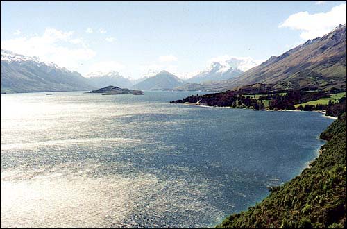 |
| Looking north from the Glenorchy road Click here for a larger version |
Watch for the notice board with a diagram identifying the mountains at the head of the lake.
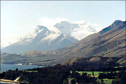 |
| Mount Earnslaw from the Glenorchy Road Click here for a larger version |
There is much to enjoy in Glenorchy itself. Be sure to read the article about this place in next week’s NZine.