Dorothy – 30/08/02
Travel from Arthur’s Pass across New Zealand’s Southern Alps to Otira and you can experience native bush, see impresssive Mount Rolleston, explore the Chasm and the Dobson Nature Walk, visit the Temple Basin skifield, view the engineering achievement of the Otira Viaduct, see rata in the awesome Otira Gorge and see for yourself the revival of historic Otira.
In winter snowy mountain tops and often icicles by the road create an icy panorama. In spring rains the waterfalls are abundant. In summer the snow recedes, mountain flowers bloom on the top of Arthur’s Pass and rata bushes bring splashes of red on the steep bushclad slopes of the Otira Gorge. In autumn the weather is more settled and the colours are richer.
In earlier times the teams of horses on Cobb & Co coaches struggled up the steepest slopes while the passengers walked, and the brakes were jammed on for the descent. Then came the years when buses had to back to manoeuvre round the sharp bends. Now the 13 metre vehicle length limit is gone, the worst hazards are removed and except when winter conditions close the route modern cars, buses and trucks travel easily over sealed roads.
Up from the village at Arthur’s Pass The road rises rapidly from the village. Do drive slowly so that you enjoy the view on your right of the Punchbowl Falls. Better still walk up the road so that you can see the mosses on the rocks, and hear the bird song and the sound of the creeks dashing over the rocks.
1.5 km north of the village on the right down below the road is Daisy Flat – a grassy patch beside the Bealey River where you can enjoy a picnic and a swim and see the rock wall along the old coach road.
The next landmark is called “The White Bridge” because of its original colour. Here the coaches would stop for the driver to collect the tickets, and the passengers would walk up the steep slope to ease the load for the horses.
From here watch for your first glimpse of Mt Rolleston – 2275 m (7,460 ft).
Jack’s Hut At 3 km from the village you come to the site of Jack’s Hut. Grace Adams’ book, Jack’s Hut (published 1968, A. H. & A. W. Reed), gives a vivid picture of life in the area from the nineteenth century days of Cobb and Co’s coaches and the paintings of Petrus van der Velden, the inspired Dutch painter, through to the 1960s. Grace Adams was the third daughter of Grace and Guy Butler who spent time first camping near Jack’s Hut and then buying the hut in 1923. Grace Butler, a well-known New Zealand artist, was inspired to paint the impressive scenery of the area and also painted Jack’s Hut. Later Guy Butler turned the old cookhouse at the village into an accommodation hostel. Grace Adams and her husband Hugh and their family also spent a lot of time at Jack’s Hut.
In Jack’s Hut Grace Adams peoples the area with characters of all sorts who passed along the road past the hut, with an especially vivid picture of Con Hodgkinson, the National Park ranger.
Upper Bealey Valley Track, The Chasm, and Margaret’s Tarn From the car park opposite Jack’s Hut the Upper Bealey Valley Track leads down to a bridge over the Bealey Chasm. If your time is limited be sure to fit this walk into your programme. (It is better to wear shoes. A friend of mine had difficulty getting down in sandals.) If time permits carry on through the forest to Margaret’s Tarn named after Guy and Grace Butler’s eldest daughter. From here there is a splendid view of Mt Rolleston. Walkers are asked not to walk around the tarn as the margin has been damaged by visitors.
Those who are reasonably fit can walk on through the forest to where the track drops down to the Bealey River, and can follow the riverbed to the gorge. Inexperienced trampers are urged not to go beyond the gorge because of the avalanche danger, especially in winter and spring. From the road to the gorge and back takes about two hours.
Mt Rolleston lookout Be sure to linger at the parking bay which gives travellers a great place to look at Mt Rolleston and take photos.
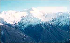 |
| Mt Rolleston |
Temple Basin Skifield At 5 km on the right there is a car park and access to the Temple Basin skifield. To walk from the highway to the Ski Club huts takes fit walkers about an hour. There is a tow for skiers’ gear.
From this walk there are magnificent views of the surrounding mountains, especially Mt Rolleston and Mt Philistine.
Arthur Dudley Dobson Memorial and top of the Pass. A little further on is the memorial to Arthur Dudley Dobson, the first European to discover the Pass, and a short distance above it the summit of the Pass.
Dobson Nature Walk There is a twenty minute loop walk and a one hour walk. Both walks begin opposite the Dobson memorial and the longer walk continues till it joins the Otira Valley Track. Board walks take walkers through bog and tussock up to a moraine ridge overlooking the Otira Valley. This walk takes you through the area where native flowers bloom in summer. A pamphlet about the walk is available at the Department of Conservation (DOC) Visitor Centre at Arthur’s Pass Village.
Otira Valley Track This track crosses an old moraine and continues through scrub and snowgrass until after an hour walkers reach the river level. In winter and spring they should go no further because of avalanche danger. In summer it is safe to walk another hour to the foot of the Otira Slide.
The Zig Zag This section of Highway 73 had always been hazardous because it was built across a huge scree slope and was subject to erosion due to earthquakes and flooding. In the last century the road was cut further and further back into the hillside, until it was 20 metres higher and 65 metres further back into the slope than it had been seventy years earlier.
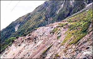 |
| The road across the scree slope |
When the practical limit to shifting the road further was reached a new way of crossing the area had to be found. Seven options were considered, including bridges and tunnels, but on engineering, conservation and economic grounds it was decided that the best solution was a viaduct to be built along the upper Otira riverbed so that the road totally bypassed the Zig Zag.
The Otira Viaduct Planning for this began in 1986 and construction began in 1997 for completion for use in the new millennium. The building of the viaduct is one of the most ambitious roading engineering projects in New Zealand in recent years.
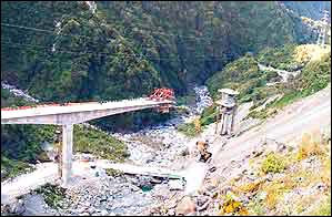 |
| The Otira Viaduct under construction |
The 440 metre viaduct is curved to make it fit in with the shape of the environment. Planners worked with DOC to consider all the issues raised by building such a structure in a National Park – protecting vegetation and the habitats of wildlife like the blue ducks, kea and great spotted kiwi.
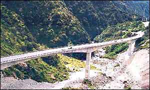 |
| The completed Otira Viaduct |
Because the site of the viaduct is one the most earthquake prone regions in New Zealand it has been designed to withstand seismic forces 40 percent higher than the usual maximum for such structures.
The road will still be subject to closures in severe winter conditions with heavy snow and icing, but it will be gritted during icy weather.
Improvements to Candy’s Bend and Starvation Point sections of the highway Here the road has been widened and supported on cantilever beams over the gorge and at the most slip prone area a protective roof has been built over the road.
Red Rata in the late summer In the late summer months the bright flowers of red rata (metrosideros umbellata) add to the beauty of the Otira Gorge. This tree is not found on the eastern side of the Southern Alps but blooms only in the moist western valleys.
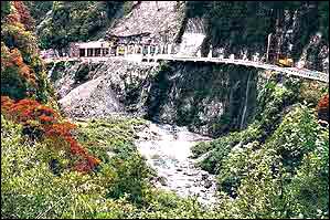 |
| Rata blooms beside the roadworks in the Otira Gorge |
Down the road through the Otira Gorge to the village of Otira Drive down the steep road through the gorge with care, even though the earlier major hazards have been removed. Then you come out into the Otira Valley and the village at Otira. This was a small but busy place when the first road was being built and when the coaches went over the Pass here the travellers heading west could breathe a sigh of relief that the steepest parts of the journey were behind them. There were once 11 inns on the way over the Pass and one wonders where there was space for them in the gorge.
When the railway tunnel was being built Otira was home for a large workforce and after it was opened there was still a sizable staff employed there by the Railways Department. Otira was the site of the powerhouse for the electric trains that were used in the tunnel before the change to diesel powered engines. The passenger trains used to stop at the tearooms at the Otira Station. Gradually the village population has been reduced as the road has been improved and Tranz Rail has reduced the numbers of railway staff. The school has closed and finally the long popular hotel was closed and the village seemed destined to become a ghost town.
Along came Chris and Bill Hennah These enterprising people have bought the hotel and the houses and are instigating a revival of the village of Otira.
Who are the Hennahs? I’ll let Chris tell you in her own words. “I was born in Hull, E Yorks England and came to NZ in 1952 (age 6) and have since become a NZ Citizen. We lived on Auckland’s North Shore until I married. Bill was born in Paeroa and brought up there and in Mt Roskill, Auckland. We married in 1970 and have three adult sons. I also have a son of 36 from an earlier marriage. We lived in Manurewa before coming down to Christchurch to visit my eldest son. We took a trip on the TransAlpine. My son mentioned that the pub was for sale and we came back by rental car and stopped to check it out. We felt sorry for the dilapidated pub and run-down houses and decided to buy.
“Living in an isolated area was not a new experience for us. We lived for about a year on a farm which was pretty isolated. We knew how to run a bar because Bill had been President and I had been Treasurer of a dart club in West Auckland. We also had a restaurant/take-aways at one time, but I find mostly the hotel is being run on what I would like if I was the paying guest! Having brought up teenage boys also helps!”
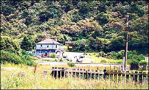 |
| The hotel re-opened at Otira |
The hotel a centre for gathering material on Otira’s history Chris Hennah describes people’s enthusiasm for the project. “The walls of the hotel are covered in photos that I have found and been given – it seems the more I put up, the more I receive from people who used to live here. Many people call in who went to school or worked here and they are very pleased to see things up and running again, especially those who drove through when the pub was closed before we bought it.”
Revival of the village at Otira Gradually people have been attracted to live in the houses.
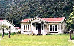 |
| Typical house built for railway employees |
During the major roadworks the staff were only too pleased to live in accommodation close to their jobs. Now families are moving in. The children go by school bus to Arthur’s Pass to attend primary school. The Hennahs are negotiating to buy the school and open it as a community centre and a place where the secondary school age pupils can do their schoolwork by correspondence.
What is the Hennahs’ dream for Otira? Chris explained, “What we are aiming for in the village is people who are self-employed in crafts, cottage industry and/or tourism ventures. We have 96 acres of land that needs fencing and developing!”
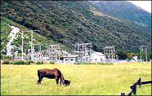 |
| Substation and open grassy area at Otira |
Preparing for your trip over Arthur’s Pass Don’t forget to take your camera and a waterproof coat. The climate is rainy as is to be expected in an alpine region where westerly winds prevail and come over the sea. There are however long periods of fine weather, and a few very heavy falls of rain account for a lot of the high annual average rainfall. In bad weather check on the road conditions on the radio or with the AA and if necessary take chains. Don’t be put off by bad weather.

