Dorothy – 30/1/98
Day or half day walks
The Peninsula Nature Walk (1.5 to 3 hours) If you want to build up your fitness gradually I would recommend that you start with the Peninsula Nature Walk. The track follows the shore of the peninsula, and is undulating and easy walking. The views of the lake and mountains are a reward in themselves, but if you are interested in plants get the pamphlet about the walk from the Park Headquarters. It is difficult to put a time limit on this walk because studying the plants and taking photos can lengthen it. Also you may choose to combine it with the next walk.
Black Hill Walk (1 to 1.5 hours return) If you walk from the Peninsula Track up the side track to Rotoiti Lodge then you can head up to the top of Black Hill and go down the steep side of the hill leading to the main road through St Arnaud. You may choose to park your car at the foot of the steep track and start the walk from there. This walk takes you among manuka and kanuka trees, growth which is regenerating after an accidental fire which burnt the original vegetation earlier this century. Among the lichen-covered rocks you will find in season white harebell flowers. The highest point of the walk is 127 metres above the lake. Don’t expect a great view from the top of the hill as the regenerating growth has grown tall enough to obscure views of all but the mountain tops. As you go down the steep slope to the main road there are koromiko and kohuhu plants which offer a bright green contrast to the manuka and kanuka trees.
Moraine Walk (1.5 hours return) You can start this walk from the point where the Black Hill Track comes down to the main road or from the West Bay camp ground. The track follows the glacial moraine on a level track to the Buller River outlet. Again you will be walking through regenerating growth of manuka, and kanuka.
Rotoiti Lake Edge Track The round trip takes six hours, but many people walk only part of the way up either side of the lake. We often walk up the east side of the lake and enjoy a picnic in one of the little bays. In January and February you may see rata flowering in one of the bays. Carry on to the head of the lake and a short distance up the Travers Valley you reach a 16 bunk hut and a bridge across the Travers River.
If you want to walk up the west side you start from Mt Robert Road. About half way up the lake you can visit Whisky Falls, an attractive waterfall so named because at one time it was the site of a whisky still. Carry on further and you come to the Coldwater Hut at the lake edge.
If you do the round trip remember that you have to walk some distance up the Travers Valley at the head of the lake to reach the bridge and cross the Travers River.
Loop Track (1.5 hours) This track goes from Kerr Bay part of the way along the St Arnaud Ridge Track until after half an hour it reaches a sparkling stream. This is an ideal spot for a rest or a picnic. At this point take the track to the right. It will take you back to the Lake Edge track which will take you back to Kerr Bay.. This is a pleasant undulating walk among the trees.
St Arnaud Ridge Walk For a much more challenging walk go up this track through the bush and above the bushline enjoy wonderful views of the lake, mountains and the Wairau Plains. You could make your target the Parachute Rocks (5 hours return), or continue up the rest of the track to the summit (6 hours return). From the top of the ridge you can see a number of mountain tarns and look down into the Wairau Valley on the other side. Always go prepared for a change in the weather. Take warm clothing.
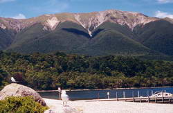 St Arnaud Range viewed from Kerr Bay (Click here for a larger version)
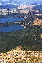
View across the village, the Peninsula and the Lake Plain from above the Parachute Rocks (Click here for a larger version)
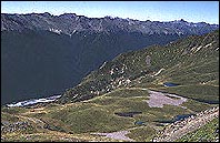
View of the Wairau Valley and the mountain tarns from the top of the ridge (Click here for a larger version)
Approaching St Arnaud ridge from the Rainbow Valley The Arnold family describe their trip: “The walk we took was an organised day trip of about 7 hours – bus from Kerr Bay to the Rainbow ski-field, short walk (400m puff) from there up onto the St Arnaud ridge nearby, for a nice view of the lake below and down the Kawatiri Valley, and a look at the alpine plants. From there the walk is along the east side of the ridge past some tarns – stony going stepping from large rock to rock in places, and then onto the razorback ridge for the last bit before dropping down the west side via a zig zag track back to Kerr Bay – through snow grass and Parachute Rock to the bush line with trees at person height, and on down through to the higher and higher bush to the lake.” Moderate agility with some staying power is needed. Moderate fitness desirable but not essential for an otherwise healthy person.
Mt Robert Ridge Walks(6 hours round trip) Start from the carpark at the end of Mt Robert Rd and walk as far as you choose on the Pinchgut Track (clearly a steep zigzag) or on Paddy’s Track. Mt Robert, like Black Hill, was the site of an accidental fire early this century. The growth is beginning to regenerate, but on the lower slopes there is very little shelter. There are beautiful views of the lake and mountains. An interesting round trip can be made by combining these two tracks. On the ridge there are interesting mountain plants in flower in January. Always go prepared for a change in the weather. Take warm clothing.
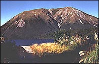 Mt Robert viewed from Kerr Bay (Click here for a larger version)
 Tramping I can’t write from experience about the longer tramps as I have a back problem which prevents me from carrying an overnight pack. Others’ accounts of their tramps make me envious.
Angelus Basin Tramp from Lake Rotoiti and Return Philippa, Kevin and their teenage family did this two day walk just before New Year. Philippa writes: “This is a comfortable two-day tramp which either returns to the starting point or alternatively finishes at the head of Lake Rotoiti.
It is favourable to start the tramp at the Mt Robert car park and proceed up the Pinchgut track towards the Mt Robert ski field. Day one is spent totally over the mountain ridges and tops from which there are spectacular views of the surrounding peaks and lower country bordering Nelson Lakes National Park.
We chose to bypass the Angelus Hut situated beside Lake Angelus, in favour of a camp area in the Hukere Valley, forty minutes walk from the hut. This was sensible as in mid-summer hut space is at a premium. Our camp area is considered a very special spot in the park, with grassy meadow, beech forest, cascading water and high peaks surrounding it. A magnificent place to stay the night.
Day two, we walked down the steep sided Hukere Stream to join up with the Travers River, then on to Lake Head hut. Here it is easiest to take a boat ride down to St Arnaud or alternatively walk out to Mt Robert car park.”
A wonderful two day walk, with a good balance of bush, open country, easy walking and steeper grades. Day 1: 5 to 7 hours Day 2: 3 to 5 hours.”
Tramp from Rotoroa to Rotoiti via Blue Lake Robert described his six-day January tramp around Nelson Lakes National Park. He and his party took a water taxi to the head of Lake Rotoroa and spent the first night at the West Sabine Hut.
“The next day we walked up the West Branch of the Sabine River to Blue Lake and Lake Constance, returning to the same hut for the night. On day three we ascended the Travers Saddle adjacent to Mt Travers and went down from there to the Travers Hut in a rocky valley. On day four we camped in the lower Travers Valley and then followed the track up Hukere Stream to Lake Angelus and stayed there at the hut. The following day we walked out along Robert Ridge to the Mt Robert car park.
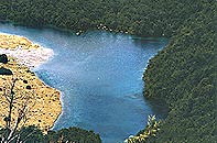 Blue Lake surrounded by bush (Click here for a larger version)
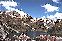
Lake Constance (Click here for a larger version)
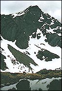
Mt Travers from the Travers saddle (Click here for a larger version)
I found the scenery magnificent, but I would recommend that the trip be done in reverse order as the climb up to the Travers Saddle when carrying a heavy pack was very tough going and unnecessarily arduous.”
Climbing Mt Hopeless
Alister commented that among the many fine climbs in the Travers Range the one up the unfortunately named Mt Hopeless (2278m), is one of the most rewarding. It offers much for the mountaineer, but also a relatively easy route to the summit in late summer for fit trampers. Although some guides say that the last 100m (ft ) should be tackled with ropes, this is often unnecessary when conditions are good.
“Access for the easiest route is from Hopeless Creek (2-3 hours up theTravers Valley from the Lake Head). Our party of three took the water taxi in the early morning to the head of the lake, walked up the Travers Valley and then followed a marked track from the Travers Valley in bush up the true right bank of Hopeless Creek for about 2 1/2 hours to the Hopeless Creek Hut just above the bushline.
After an overnight stay in the hut we made an early start by following a wildlife trail up a rocky hump on the east bank of the stream to the east of the hut. We climbed as far as the fork in the stream, then up a steep tussock slope to the south until we reached rocky terraces and a tarn. We had a good view of the upper part of the mountain at this point.
Then we ascended a snowgrass slope to a gut angling steeply up to the NE ridge. This slope can be snowy even in summer. We followed this narrow ridge south to the summit, taking care with loose rubble in places. We enjoyed the wonderful views of surrounding peaks and Lake Rotoroa.
We returned to the hut and stayed there overnight before returning to St Arnaud.”
Beauty of the area can be experienced by everyone. The above walks can be done by those who are fit, but tours are available for the less fit or disabled. Read NZine next week for information on tours and the tour operator, Colin Clarke. Or if you haven’t already, check out the
first article in the series…

