– Dorothy – 28/11/97
When anyone looks up at the Port Hills from Christchurch the feature standing out above the silhouette of the hills is the 119 metre TV tower on Sugarloaf. The choice of this site for the tower is an indication of the all round views that can be seen from Sugarloaf Hill, but for a full appreciation of the scenery and a varied and pleasant walk try a loop track walk on Mitchells Track and Cedrics Track or Gilpins Track.
Origin of the names of the tracks Mitchell is the name of a Governors Bay landowner who was very supportive of the development of tracks on the Port Hill and gave the Christchurch City Council a sum of money to develop the track which now bears his name.
Gilpin’s track is called after Mr H Gilpin who was Director of Parks and Reserves from 1955 to 1979 – a role which involved him in the development of the tracks in the Summit Road area.
Cedric’s track is named after Cedric Turner, a very dedicated member of the Summit Road Society for nearly fifty years. He was a member of the group known as the Hill Work Gang who have donated a day a week to work on the tracks year after year.
Variety on the walk This round-trip walk gives views of Lyttelton Harbour and of the Canterbury Plains and the distant mountains and takes you through some original native bush and across open grassy areas. Mitchells Track is part of the Crater Rim walkway which goes along the hilltops from Gebbies Pass to Evans Pass.
Parking
 |
| The view across the city to the mountains from the Sugarloaf carpark. (Click on the image to get larger version) |
You have a choice of places where you can park your car – at the Sign of the Kiwi, at the carpark below the television tower, and at the viewing area at the head of Bowenvale Valley. We chose to park at the Kiwi on our most recent walk. It was the day of the Santa parade so there were fewer walkers than usual and plenty of parking.
Facilities At the Sign of the Kiwi there are tearooms, a shop and toilets.
Footwear The track provides comfortable walking except after heavy rain. We recommend walking shoes or boots rather than sandals for this walk as it is over uneven ground in places.
The walk Don’t be put off by the steepness of the steps at the beginning of the track. There is a strong handrail. Take the first few minutes slowly, and you will find that the rest of the walk is much easier going on undulating track. Seats at strategic places along Mitchells Track give places we welcomed for resting, viewing the scenery and taking photos.
Mitchells Track After about four minutes you reach the sign pointing to Mitchells Track on the right amd follow the orange markers. This track leads you along below rocky bluffs and through native bush which once would have covered the harbour side of the hills and the valleys that face the plains. There are no large trees as these were milled before the area became a reserve.
A few minutes along the way you cross a stile and enjoy a wide view of Lyttelton Harbour and the settlements on the far side.
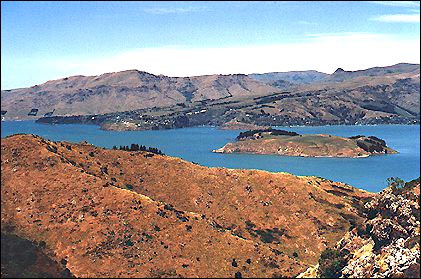 |
| Lyttelton Harbour viewed from Mitchells Track showing Quail Island, Charteris Bay, Church Bay and Diamond Harbour. (Click on the image to get larger version) |
From this point on the walk passes through bush. As we walked we noticed five finger – kuakou, coprosma, mahoe (also known as whiteywood and on Banks Peninsula sometimes called cowleaf), flax, titoki (the native ash), matipo, ferns, papaumu (broadleaf) and kanuka. Some hebes on this track are a rare variety, found only on the Port Hills.
About ten minutes further along the track there is a path to a lookout and a stone seat. From here you can see from Governors Bay at the head of the harbour to the harbour entrance. To the South over Gebbies Pass there is a glimpse of the open sea beyond Lake Ellesmere.
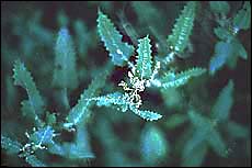
Just past here beware of brushing your bare legs on stinging nettle – ongaonga
, a native New Zealand tree known as urtica ferox.
|
|
| Stinging nettle – ongaonga |
A little further along the track there are some tree fuchsias – kotukutuku (which is the Maori word for a walking stick). You can identify these by their reddish-orange peeling bark. Note also five finger – puakou, with black berries in early summer, and the peppertree – horopito, recognisable by its leaf with dark reddish spots.
As we walked we heard bellbirds in the trees and saw a silvereye quite close on a small shrub.
Some fifteen minutes from the last lookout there is a stone seat from which you can view the upper harbour and the jetty at Governors Bay.
A few minutes more walking brings you to the end of Mitchells Track at a car park on the Summit Road.
The return trip on the loop track
 |
| Looking south along the Southern Summit Road from the Sugarloaf carpark. (Click on the image to get larger version) |
The return trip begins on a track above Mitchells Track. You have the option of returning along Gilpins Track which crosses the rocky bluffs at a higher level than Mitchells Track. However, for a variety of views we recommend following the lilac markers and taking Cedrics Track which runs off on the right some five minutes along the upper track which starts from the stile.
Cedrics track and the panorama Cedrics Track sidles round the hill across mixed grass and tussock land and in less than fifteen minutes brings you to the carpark below the tower. Turn off on the left of the road and continue on Cedric’s track for another fifteen minutes to the Sign of the Kiwi.
As you walk there are views down Bowenvale Valley, and across Christchurch to Pegasus Bay in the east, and the Kaikoura mountains to the north-east. Looking across the plains from the carpark you can see the foothills of the Southern Alps including the Puketeraki, Craigieburn and Torlesse Ranges, Mt Hutt, Mt Somers and Mt Peel. Closer there is the range with Mts Grey, Karetu, Thomas, Richardson and Oxford. Turning further south you can see along the Summit Road, the land at the head of the harbour and the sea beyond Gebbies Pass – a wonderful panorama on a clear day!