Dorothy – 15/02/02
You may feel regretful about pulling away from the shore of beautiful Lake Wanaka, but there is no occasion for regrets as you are heading into a wonderful scenic area as you travel through the Haast Pass to the West Coast.
Follow the signs as you leave the township and at the junction turn left to drive along State Highway 6. You will cross the Clutha River at Albert Town and drive along flat to undulating country to Lake Hawea Hydro Dam – 10 kms (6.25 miles) from Wanaka.
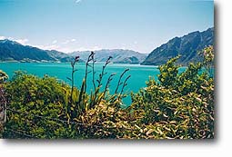
In 1958 this beautiful lake was raised some 20 metres (65 feet) by damming the outlet to provide extra storage of water for the Roxburgh Hydro-Electric Station. The beaches and the gently sloping shoreline were drowned by the raising of the lake, so it has a different appearance from Lake Wanaka. The colour of the water in the lake is an instant attraction for photographers. The vivid blue results from the depth of the water – 410 metres (1,345 feet).
|
|
| Looking from the viewing point Photo source Bill Moore |
|
|
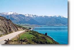
| Looking towards the neck |
|
|
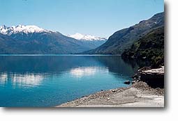
| Reflections in Lake Wanaka |
The road then follows the shore of Lake Hawea to the Neck, a narrow strip of land separating Lakes Wanaka and Hawea. Part of the way along the shore there is a viewing point with a view of Silver Island and some interpretation panels.
The lake beds of Hawea and Wanaka were gouged out by the Hawea and Wanaka Glaciers. The strip of land known as the Neck was where a branch of the Hawea Glacier joined the Wanaka Glacier. In early days a Maori camp was situated at the Neck.
The road drops to lake level before rising over the Neck, and then follows the shores of Lake Wanaka. We had the good fortune to travel through this area on our last visit on a fine calm day and the mountains were clearly reflected in the lake – a most impressive sight.
Leaving the head of Lake Wanaka the road then runs through an open valley to Makarora.
Makarora The area around here was once forested densely. From the 1860s foresters felled kahikatea, matai and silver beech. The timber was pitsawn and floated on rafts down Lake Wanaka and the Clutha River to supply the needs of the Central Otago gold towns.
Mount Aspiring National Park At Makarora the road enters Mount Aspiring National Park. From 1936 onwards there was strong interest in the formation of this park, especially among mountaineers. After the Westland National Park was opened in 1960, and the road from Wanaka reached Haast in the same year the interest grew. In March 1964 a public meeting was held in Dunedin to discuss the issue. Over thirty organisations were represented among the hundred people who attended. They put pressure on the Government and the Mount Aspiring National Park was gazetted on 10 December 1964. This was New Zealand’s tenth national park.
The headquarters of the park are at Wanaka, and there are ranger stations at Makarora and Glenorchy.
World Heritage status In December 1990 the park was given World Heritage status. Aspects of the park are the subjects of scientific research – vegetation surveys, the impact of deer grazing, the movement of the Dart Glacier and the rate at which it is receding, the birdlife, the invertebrate life, the migration of beech forest and the spread and control of exotic animals and plants.
Driving through the Haast Pass The Haast Pass road follows an ancient trail used by Maori travelling to the West Coast in search of pounamu/greenstone/jade/nephrite. The name for the trail is Tiora-patea, meaning “The way is clear”. The Haast Pass is the lowest across the Main Divide (563 metres above sea level).
A gold prospector called Charles Cameron is considered to be the first pakeha to find the pass. He went alone to the West Coast wanting to reach there by the most direct route from Dunedin, and crossed the pass in January 1863. He buried his powder flask to the west of the pass. Close behind him came Julius von Haast. His party of five found the journey very difficult with constant rain and flooded rivers which slowed their progress and led to a shortage of food. Haast named the pass after himself and claimed to be the first pakeha to have travelled through it, but the discovery of Cameron’s flask discredited this claim.
Now with a sealed road travel through the pass offers easy motoring and there are a number of well-marked walks along the way.
Walks along the road Makarora Bush Nature Walk, Makarora village If you take this 20 minute walk you will be rewarded by seeing the type of vegetation that once grew in the valley – lowland podocarp/silver beech forest, with large specimens of matai, miro, kahikatea and silver beech. There is also a pitsaw display which shows the early technique used for milling timber.
Boiler Flat Here there is a picnic area with picnic tables and toilets. In the picnic area you can see a rusting steam engine left after the early sawmilling in this area.
Blue Pools
|
|
| The swing bridge near the Blue Pools |
This walk, 30 minutes return, proved a highlight of the trip for our party. The gravelled path gives easy walking through silver beech, and boardwalks and netting complete the walk to the viewing platform. From there you may see large brown and rainbow trout feeding in the crystal-clear pools in the Makarora River. There is a swing bridge over the river and from there a track goes on to Camp Flat, a 4 hour round trip.
Cameron Flat From here the Cameron Creek Walk leads to a viewing platform which gives views of the Makarora Valley and the surrounding mountains. Toilets and a barbecue area are provided in the picnic area and for a small fee overnight camping is permitted.
Davis Flat Here there is another picnic and camping area with toilets and a barbecue area.
A track from here follows the old “Bridle Track” used for travel between the West Coast and Otago and finishes at the summit of the Haast Pass. The walk takes one and a half hours one way, but if you want to walk it one way you will need to use two cars to ensure transport at the far end. The walk passes through beautiful beech forest and follows the upper reaches of the Makarora River. The two river crossings are bridged.
Haast Pass (563 metres above sea level) A memorial here marks the summit of the pass and acknowledges the dedication of those who built the road.
Fantail Falls
|
|
| Fantail Falls Photo source Alister Hunt |
These falls must be the most popular and often photographed attraction on the road. They can be seen from the road, but it is best to take the bush walk to the riverbed to appreciate them fully. It takes only five minutes return to do the walk, but most people spend time taking photographs of the area.
Thunder Creek Falls/Gates of Haast Again a short walk – five minutes return – gives views of spectacular water falls appropriately named Thunder Creek Waterfall – 28 metres high. They drop from the level of the glacier ice when a glacier was carving out the future bed of the Haast River 10,000 years ago.
There is wheelchair access to the Falls.
In the Gates of Haast gorge just above the waterfall track enormous boulders and steep walls are evidence of the schist which is the basic rock in these mountains. The road maintenance workers from Haast have to keep checking this area to keep the road open as the walls of the gorge crumble at times.
Pleasant Flat Here there is another five minute bush walk – a loop walk from the picnic ground. There is a landscaped picnic and camping area, with great views of Mt Hooker. There are display panels explaining features of Mt Aspiring National Park.
Roaring Billy The walk to these falls takes 25 minutes return, but it is well worth taking the time as there are interesting ferns along the track. At the end of the track there is a good view of the falls across the Haast River.
The Alpine Fault The traveller does not notice it but four kilometres east of the township of Haast the road crosses the Alpine Fault.
Haast township and Haast River mouth bridge The township was originally a Ministry of Works camp when the road was being built, but it has developed as a service centre for those living in the area, and since the area has been declared Te Wahipounamu, The South-West New Zealand World Heritage Area it has become an increasingly important tourist centre.
The 732.4 metre Haast River mouth bridge was completed in 1962 and stands some 3 metres above the highest known flood level.
For further information read about Neville Peat’s guide book Wanaka: The Lake Wanaka Region.


