Dorothy – 14/01/05
The Port Hills south of Christchurch provide a range of interesting walks, mountain bike rides and scenic drives close to the city. The best known walk is the Harry Ell Walkway which runs from the Sign of the Takahe to the Sign of the Kiwi at the summit of Dyers Pass. A round trip can take in Thomson Park, Latters Spur Track, the Memorial site of the 19th Infantry Battalion and Armoured Regiment, Victoria Park, and Elizabeth Park. In Victoria Park there are wheelchair tracks through the trees and to the Visitor Centre.
Who was Harry Ell? Harry Ell, a Member of Parliament for twenty years representing the people of Christchurch, had a vision for the Port Hills. He wanted a road to be built along the summit of the hills, land to be set aside as reserves, walking tracks developed, and rest houses to be built along the way. He was an enthusiastic walker himself and knew well all the narrow tracks. The road he planned was to be mainly for trampers and to run for fifty three miles from Godley Head at the entrance to the Lyttelton Harbour to Akaroa.
Ell was a man of extraordinary determination, and although people found working with him very difficult many of his plans came to fruition. By the time of his death in 1934 the road from Godley Head to Gebbies Pass was completed and three roadhouses (two named after New Zealand birds) had been built – The Sign of the Kiwi, The Sign of the Bellbird and the Sign of the Packhorse. These were solid stone buildings and were intended to offer walkers meals and a bed.
The Sign of the Takahe was planned on such a grand scale that money was a problem and it was not completed until 1949 when it was taken over by the Christchurch City Council. It was built in grey stone in Tudor-Gothic style. Much of it was built by craftsmen by hand, many being employed during the Great Depression on a relief work project. It reflects much of Canterbury’s early history being decorated outside and inside with the heraldic emblems of early settlers, governors and supporters of the Summit Road Scheme.
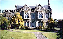 |
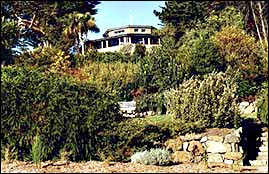
| Sign of the Takahe |
At the Sign of the Takahe restaurant you may enjoy a Devonshire tea or a moderately priced a la carte lunch and look at Harry Ell’s most ambitious project – now long valued as an asset to the city.
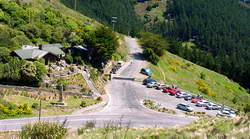
Walkway access You can reach the Sign of the Takahe by car via Hackthorne Road or Dyers Pass Road and there is parking available on the adjacent streets and in some parking bays further up Dyers Pass Road. There is also a small parking area at the Sign of the Kiwi.
You can catch a bus from the city to the Sign of the Takahe – Cashmere number 10, or Dyers Pass number 67. Call at the Bus Exchange for a free timetable or phone 366 8855 for information.
Toilets These are located near the Sign of the Takahe, at the Sign of the Kiwi, and at Victoria Park.
What to wear and what to take Walking shoes are best for comfort. It is always wise to take a jacket or parka. A warm hat is useful on cold days and a sunhat and sunblock are strongly recommended in the summer.
View of Christchurch and the mountains Before you begin the track you may like to walk to the viewing point in the park beside the Takahe. From here you can see the city and the sea to the east, and if the weather is favourable you may check the plane table and see the mountains in the direction of the Southern Alps (including Mt Hutt) to the west, and the Kaikoura Mountains to the north.
All-year track The track is good to walk all year round and drains quickly after rain. It is well sheltered from the easterly wind and on one recent winter day when the easterly was bitterly cold I walked the track in pleasant temperatures without a breath of wind.
The track begins just above the Sign of the Takahe and may be reached from Dyers Pass Road or Victoria Park Road.
 |
| Cashmere Spur and Bowenvale Valley Reserve Click here to view a larger version |
The track is above the road and is well signposted. Much of it is among trees but there are ample clearings to give views of the plains and the Alps.
A popular track The track rises at an easy gradient suited to walkers of all ages. Whole families walk the track and seats along the way provide places to rest. The track is so popular that you meet many people walking or jogging, and children being carried on their parents’ backs, even on weekdays.
Birds along the way Last time that we walked the track we saw and/or heard bellbirds, fantails, chaffinches, greenfinches, grey warblers and a native pigeon.
Vegetation There is a wide range of trees and shrubs, exotics and natives, and even in winter there is some colour. Arbutus trees provide colour with their berries and a feast for the birds. Wild sweet peas flower along the banks for much of the year. Apple trees along an open section of the track are evidence of the walkers who have tossed away their cores, and provide a splash of blossom in the spring or winter colour with apples left on the trees. Many of the natives have been planted by school children in Arbor Day projects.
Views from the top of Dyers Pass At the Sign of the Kiwi walkers reach the top of Dyers Pass. From here there are views of the Canterbury Plains and the mountains to the north and west, and the Lyttelton Harbour to the South.
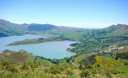 |
| Lyttelton Harbour taken from a vantage point opposite the Sign of the Kiwi |
The Sign of the Kiwi The second of Harry Ell’s roadhouses offers simple hospitality in a welcoming atmosphere. Last time I visited I ordered a plunger of coffee which yielded two cups and a delicious toasted sandwich with an egg inside – all for a modest price.
 |
| The Sign of the Kiwi |
If you wish to take your own food there are seats in front of the building where you can sit and enjoy the view as you eat.
Alternative return trip I am always tempted by a walk which is a round trip. For a different and interesting route back to the Takahe walk along the Summit Road to the left (east) at the top of the H. G. Ell walkway and walk to the first parking bay. Above the road there is a small reserve called Thomson Park. You may like to rest in the stone shelter there or head directly downhill on the Latters Spur Track. This will take you through trees and at times down stone steps to Victoria Park. Take care on the short portion of the track where the markers show that it is combined with the mountainbike track.
From this track there are views of the city and the coastline north of Banks Peninsula, across Pegasus Bay to the Kaikoura mountains.
When the track levels out there is a choice of walking to the left or the right of the hilly area ahead. On that hill is a very special memorial area: the Memorial to the Nineteenth Infantry Battalion and Armoured Regiment, Second New Zealand Expeditionary Force 1939-1945
The soldiers of the Nineteenth Infantry Battalion and Armoured Regiment (South Island Branch) who fought in the Second World War are honoured in a beautiful living memorial here in Victoria Park. The planting in the area is full of symbolism, and plaques give clear information about the history of the Battalion and Regiment and the significance of the area.
Port Hills Visitor Centre Until recently anyone visiting Victoria Park saw on the top of the hill a large round stone shelter built in 1898 in recognition of Queen Victoria’s Diamond Jubilee in 1897. As a child I remember thinking it dark and mysterious. Now the wind no longer howls through the shelter. It has been glassed in and made into an attractive Visitors’ Centre.
 |
| Port Hills Visitor Centre |
Do take time to pause, relax, and look at the displays before heading down Victoria Park Road to the Takahe.
Time and distance The length of the walk is 4 kms and it takes between one and two hours, depending on how long you spend looking at the view or watching the birds or taking photographs.
Wheelchair access If you have enjoyed the views, the trees and the visit to the Visitor Centre and want to share these with someone in a wheelchair you could combine a car trip with a pleasant wheelchair walk among the trees and up the wheelchair track at the back of the Visitor Centre.
Mountain bike tracks Mountain bike riders frequently follow the road to the Sign of the Kiwi, turn left along the Summit Road and ride as far as the first parking bay. From there clearly marked tracks lead down to Victoria Park Road hills or to the right parallel with the Summit Road to the top of the Bowenvale Mountain Bike Track. The last part of the track is very steep so care is necessary, especially for inexperienced riders.
Dogs must be restrained by a leash at all times. A special separate dog exercise area is located to the east of Victoria Park road below the park.