|
Dorothy – 23/04/04
A bus trip following the course of the Heathcote River with a well-informed and enthusiastic guide greatly changed my view of this river. The trip gave us an insight into the history of the area, its role as a food source and a route for Maori crossing Canterbury, navigation by early colonists, the flooding problems and control measures, the Wigram Retention Basin, the Malthouse, the Farnley Reserve, Merchiston historic house , the Woolston Cut, Steam Wharf Stream, the towpath walk, and the saltmarsh near the Avon-Heathcote Estuary.
A river with a varied history During much of the twentieth century the Heathcote River was regarded as far less attractive than the Avon River which features in so much of the tourist publicity for Christchurch. This is not surprising. Industrial waste had been discharged into the lower reaches for many years fouling the water, the banks and bed, and little was known of its early history and its role for Maori in pre-European times.
How Maori used the Heathcote Maori valued the Heathcote as a source of shellfish, and set traps for whitebait, flounder and eels. In the swamp forest along the river they gathered water fowl and forest birds. In its upper reaches near Wigram airfield the Heathcote is close to the head of the Halswell River.
The Ngai Tahu are thought to have dragged their canoes from one river to the other, thus being able to travel by water from Waihora (Lake Ellesmere) to Otautahi (Christchurch).
European settlers used the Heathcote for transport The First Four Ships bringing colonists organised by the Canterbury Association arrived at the end of 1850. By 1851 a ferry was operating across the Heathcote. The settlers soon discovered the value of the river for transporting goods, but bringing goods to Christchurch from Lyttelton was a hazardous and costly journey.
Soon sailing ships began transporting goods from Lyttelton. First they had to sail through the shifting sands of the Sumner Bar, and long delays, or worse still shipwrecks, were common.The Heathcote was tidal for eight miles, but the sharp bends, the wind from the hills and the swamp flats made navigating difficult. To assist the ships a towpath 25 feet wide was built on each side of the river. Bullocks and horses pulled the ships through the most difficult sections, except where the ground was too swampy for the animals to walk across it. Rowing boats from the larger vessels pulled them through these stretches.
Wharves were built on the north side of the river and industries were established with river access. One wharf was near the point where the Steam Wharf Stream joins the Heathcote. Here there was room for the ships to turn and the Steam Wharf became a busy port. Cargo was taken to the town by carts and drays pulled by horses or bullocks.
Once the railway to Ferrymead was opened in 1863 and the Lyttelton railway tunnel was opened in 1867 the role of the Heathcote in transport diminished greatly.
The towpath has recently been restored as a walkway and native plants have been cultivated along it.
1970 – Trade Waste Sewer upgrades river’s water quality Early industry developed along the Heathcote River and the Lyttelton railway line and much industrial waste was pumped into the river, resulting in murky water and unattractive banks in the lower stretches of the river near the Avon-Heathcote Estuary until 1970 when the Christchurch Drainage Board (CDB) built a Trade Waste sewer which collected these wastes and pumped them to the sewage treatment works at Bromley. There was an immediate and continued improvement in the water quality.
The bus trip Our exploration of the Heathcote began near its source at St John of God Hospital. Next stop was in Warren Crescent where a short walk took us to the retention basin and wildlife reserve at the back of Wigram Airport. This pond collects the storm flows from the Hornby area and discharges them at a controlled rate into the river so that flooding further down the river system is not aggravated.
We followed the river along the foot of the Cashmere Hills beside banks planted with willows. Turning into Colombo Street we were able to see the old Malthouse, built in 1867 and renovated in recent years as the home of the Canterbury Children’s Theatre.
Following the course of the river we came to the Centaurus Road shopping centre and the Farnley Reserve, so named because the Farnley Brick and Tile Works built in the nineteenth century was on the nearby hillside. This delightful area has been created along the bank of the river behind the shops where not long ago there was knee-high grass and litter, including discarded bricks and tiles.
The Christchurch Soroptimists and the City Council combined their efforts and from 1994 they worked to develop a reserve. Other community groups joined the Soroptimists in clearing the area and preparing it for cultivation. Community planting days were held to plant the area with riverbank plants that would have grown there long ago – rushes, sedges, kahikatea, rimu, native shurbs, pungas and ferns. The walkway is paved with bricks, and seats, a boardwalk, timber jetty and steps have been built. Bing Dawe’s sculpture of bronze eels swimming through paving tiles and loose stones has a central position.
The Soroptimists’ work was acknowledged at the opening of the reserve on 26 September 1998, fifty years since their community service began. A further honour for their work came at the Soroptimist International Convention in Finland in 1999 when the Christchurch branch received an award for “exceptional service in the area of environment.”
Merchiston, a house with a history, at 80 Riverlaw Terrace, was the next stop. Built in 1879 for Andrew Anderson the house is named after Merchiston Castle, the school he attended in Scotland. The house began with four rooms and was expanded to meet the needs of a growing family. The property was bought by Ewart Smith in 1927. Methodist churches held social functions there and Christian Fellowship groups and Girls’ and Boys’ Bridgades now use the house for meetings and small camps.
In Clarendon Terrace we were able to view the remains of the old wharf at the upper end of the towpath.
Heathcote flooding and control measures The Heathcote River has often been praised for its slow flowing between shallow banks, but this has been the cause of numerous floods. Between 1925 and 1960 sixteen major floods occurred.
People were attracted by the appearance of the river upstream from the industrial area and had their homes built to look out on the river with its grassy banks and willow trees.
Many home owners in Richardson, Aynsley and Clarendon Terraces had their sections and garages flooded and the flood waters entered 23 houses. The situation was aggravated by the slow flow of the river around the Woolston loop.
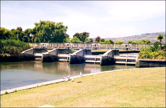
The choice of schemes to remedy this situation was to widen the river bed around the Woolston Loop or to construct a flood channel across the neck of the loop. The latter scheme, called The Woolston Cut, was to be much more effective in reducing the flood levels upstream, and would cost one third of the river widening scheme.
The Woolston Cut This was constructed by the CDB in 1986. It was 510 metres in length and cost over two million dollars.
Environmental problems resulted because saline water was able to travel much further upstream. Along the banks as far upstream as the Opawa bridge most of the trees died. To remedy the situation control gates were built at the upstream end of the Cut and left closed except in times of flooding. When they are opened the flood waters can flow rapidly through the Cut instead of slowly around the loop.
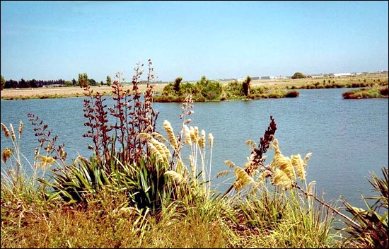
The tour concluded with a short walk to the bird hide and the information platform beside the Towpath .
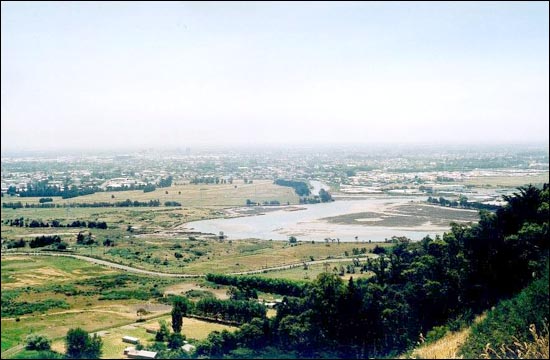
Some weeks after the bus trip my husband and I explored the river again and walked up the Heathcote Quarry track from Bridle Path Road and photographed the lower Heathcote – a valued reminder of an interesting River.
|