|
Dorothy – 18/02/05
The Denniston Incline was described by the local residents as “the eighth wonder of the world”, and was recognised the world over as a fine engineering achievement.
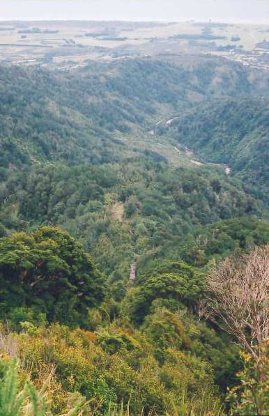
From its opening on 24 October 1879 till its closing on 16 August, 1967 it carried an estimated 12,600,000 tons of coal from the Mount Rochfort Plateau, down 1700 feet to the rail head at Waimangaroa.
The beginnings In 1859 the explorer, John Rochfort, and his party discovered coal in a creek bed when crossing the Papahaua Range. In the following year the Nelson Provincial Council sent the geologist and explorer Julius von Haast and James Burnett, a colliery engineer, to check on reports of gold and coal on the West Coast. On crossing what is now called the Rochfort plateau below Mt Rochfort Haast found a rich seam of coal and called the area Coalbrookdale, after the mining district in Shropshire, England.
Coal began to be mined at the Waimangaroa Mine which made what was now called the Mt Rochfort Railway more urgent. The line from Westport to Fairdown was completed by 1875, and in 1875 tenders were called for laying the formation of section two from Fairdown to the Waimangaroa River. Engines, trucks and carriages were imported and unloaded at Westport Harbour. The line was extended to the Wellington Company Mine and a further extension took the line to Conn’s Creek in 1877.
In 1873 William Cooper and Robert Blair Denniston carried out topographical and mineral surveys on the Mount Rochfort Plateau and after their report that possibly 72,600,000 tons of extractable coal was to be found there the Westport Colliery Company was formed in Dunedin in 1878, and in that year it gained ownership of the railway from Waimangaroa to Conn’s Creek.
To bring the coal down from the Mt Rochfort Plateau consideration had been given to a railway like that from the Dun Mountain to Nelson, but it was necessary to find a system which would return the empty wagons to the top. James Burnett had recommended a self acting incline, as straight as possible. In 1878 this was the system that was adopted. Work began on the construction late that year. In the following year on 24 October 1879 the Incline was officially opened.
A bridge ten feet wide was built across Conn’s Creek, with the decking 42 feet above the water, and 40lb rails were laid on 7 foot sleepers. From there a timber viaduct took the rails up to Denniston. The grades were as steep as 1 in 1.25. Trucks were exchanged between the Upper and Lower Inclines at the Middle Brake and here the grade was 1 in 120. On the Upper Incline it was as steep as 1 in 1.69.
The fall from the bins at Denniston to Conn’s Creek at the foot of the incline was 1,700 feet and the length of the track was 83 chains. The track consisted of two sections. The upper incline was 33 chains long and the vertical fall was 830 feet. The lower incline was 50 chains and the vertical fall was 864 feet.
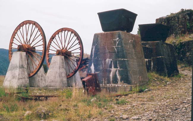
The steepness of the Incline meant that a reliable braking system was of the utmost importance particularly as it had to control wagons weighing at least 12 tons when fully loaded. Water was used to check the action of the pistons and at each stroke it was drawn off and replaced by fresh water, because the intense pressure applied would make the water boil. There was a strap brake round the centre of the drum to be used in an emergency or to bring a load to a stop. The brakesman could wind it up tight to put it into action.
On the incline the weight of the full wagon going down pulled up an empty wagon. Steel wire rope controlled the wagons. The rails were laid so that the rope from the wagon ascending the line was wound around its side of the drum and the rope on the other side unwound and let the descending wagon down the incline. The reverse procedure happened with the next full wagon.
At times the wagons went at speeds up to 80 kilometers (50 miles)per hour. In “The News”, Westport’s community newspaper, on Monday, November 17, 2003, Mr Arthur Allot who had worked on the Incline said that the brakeman’s job was to regulate the huge water-powered pistons by altering their water supply to alter the brake’s drive. This affected the speed of the wire ropes which controlled ascending and descending wagons along the line. On average, he said, fourteen wagons an hour arrived at the Denniston brakehead. A brakeman’s judgement was the key to a smooth operation as men scurried about hooking and unhooking when a wagon appeared.
All hell would break loose if a shackle holding a wagon to the incline’s rope pulled loose creating a runaway, leaving those working further down the incline at its middle brake in peril.
Getting to Denniston In the early years the only way to take people and goods to or from Denniston was in the wagons on the incline. At first the conditions on the cold uninviting plateau involved such hardship that it was regarded as no place for women, but the pioneering spirit was strong in New Zealand women in the nineteenth century and soon they began to join their menfolk who were mining in Denniston. Some found the trip up in the truck on the incline so terrifying that despite the hardships in living on the plateau they did not come down for years. After a death on the Incline in 1883 and another in 1884 and public pressure to get a foot track built, in 1885 a winding foot track was opened up and riding on the trucks on the Incline was forbidden.
Transport on the Rochfort Plateau An endless rope took trucks of coal across the plateau from Whareatea and Ironbridge mines to the bins at the top of the Incline. On the skip road were a tunnel and a viaduct. This skip road was a hazard for people who had to use it to gain access to houses built along either side.
Maidie Meek, a former Denniston resident, recalls being taken along the skip way by other children when she was four years old. When they were crossing the viaduct she made the mistake of looking down and realising the height of the viaduct. She froze with fear and a man had to come and carry her back to safety.
In 1952 the skip way was replaced by an aerial monocable to carry coal from the Whareatea and Escarpment mines to the bins. These mines were developed after production ceased at Ironbridge and Coalbrookdale. Fire broke out in the Ironbridge Mine and has continued to burn.
The beginning of the end Changes took place in the town of Denniston on the Rochfort Plateau, but the Incline continued to carry coal profitably until 1965 when the first difficulties began to be reported. The railways began to write off the two main types of wagons used on the Incline, and no satisfactory replacements were found. There was a big decline in the demand for coal. It was not possible to cut the number of men working on the Incline, so it became uneconomic and was closed. The coal was transported out by trucks. On 16 August 1967 the Incline and the branch railway line that took the coal at the foot of the Incline were both closed. After the closure trucks transported by road the coal brought to the bins on the aerial monocable.
The Inangahua earthquake If the Incline had not been closed at that time then it would have had to cease operations after the Inangahua earthquake in the following year on 24 May 1968 as it wrecked the upper part of the Inclline and buried it under a huge rockfall.
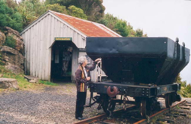
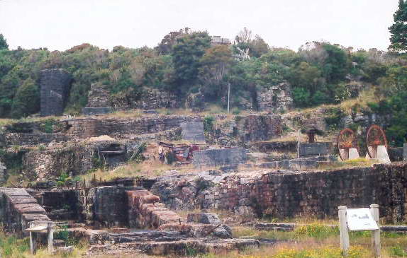
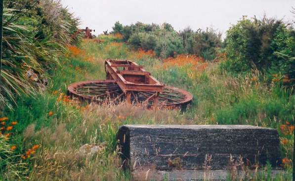
In 1969 tenders were called for the recovery and removal from the Incline of all material, including the sleepers and rails. Enough is left, however, for interested people today to envisage what it would have been like to see the Incline functioning. Interesting information is displayed in the information shed.
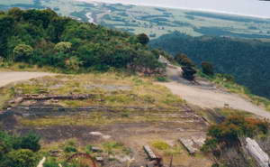 |
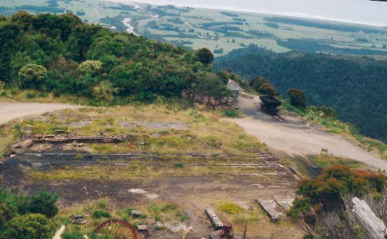
| Looking down from the site of the holding bins to the Information Centre. The flat land on the coast and the Tasman Sea can be seen in the background. Click here to view a larger version |
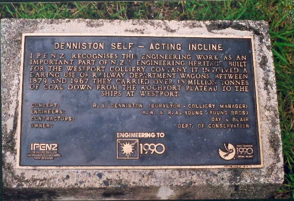
IPENZ recognition In 1990 the Institution of Professional Engineers New Zealand (IPENZ) gave special recognition to a number of engineering works which were considered to be an important part of New Zealand’s engineering heritage. The Denniston Incline was considered to be one of these and a plaque on the site of the Incline records this honour.
|