Dorothy – 22/10/99
The Mount Pleasant Bluffs Track offers an interesting walk and great views.
It takes about two hours one way. It is part of the Crater Rim track which extends along the Port Hills above the Summit Road from the top of
Gebbies Pass in the south to Godley Heads in the north east.
It is best to walk the Mount Pleasant Bluffs Track on a fine day without a
strong wind. We wanted to walk the track one way so a group of five people went in two cars. The simplest route to get there is to drive to
Sumner and take the road to Lyttelton. You can park one car at the top of
Evans Pass above Sumner. Turn right and follow the Summit Road to a small
parking area just before the hill where you see the Gondola building. Park
the second car there.
Go through the gate at this point and turn left along the Crater Rim Track.
This track first takes you along through some patches of bush.
The track then follows under the Mount Pleasant Bluffs, high vertical cliffs, on the Lyttleton side of the hill. These cliffs are popular with
rock climbers and you will often find them there practising their skills on
a Sunday afternoon.
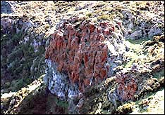
Some of the bluffs are covered with red lichen.
|
|
| Looking back at the lichen covered bluffs |
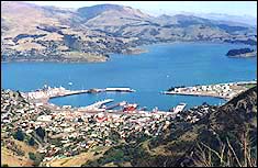
There are clear views of the Lyttelton harbour, Lyttelton town and the wharves, and the bays on the far side of the harbour.
|
|
| View of Lyttelton from below the Bluffs |
When we walked the track recently on a Sunday afternoon it was a still day
and the sounds of Lyttelton could be heard clearly – including the historic
tug going out on a sightseeing tour, loading on Cashin Quay, the container
wharf, and even the call out for a fire engine attending a scrub fire. We
had a grandstand view.
The track suits walkers of moderate fitness as it goes up and down along
the foot of the bluffs with some moderate sized rocks on the track. It is
best to wear strong shoes and carry a warm jacket as the wind can be fresh
at the top.
After just over an hour’s walking you reach old fortifications – gun emplacements from World War 2. From that point on the walking is on a track over grass and tussock leading gradually down to the top of Evans
Pass where we parked the first car.
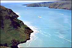
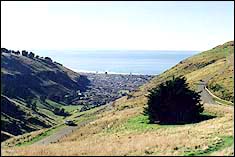
From this part of the walk you have views of Lyttelton Harbour out to the
open sea, and of Sumner and beyond up Pegasus Bay to the north. On a clear
day you can see as far as the Kaikoura Mountains beyond.
|
|
| View towards the Lyttelton Harbour entrance from the track |
|
|
| View of Sumner from the track |
An alternative outing without a car On a previous occasion when there were only two of us walking we caught the
bus from the centre of Christchurch to Sumner, walked up the Captain Thomas
track to the top of Evans Pass and walked the Mt Pleasant Bluffs track from
that end. We ate our lunch on the top of Mt Pleasant and then walked under
the Bluffs to the gate below the Gondola building. We turned right on to
the Summit Road and walked to the turn off on the left to the road that
runs down through the suburb of Mt Pleasant and caught the bus back to the
city at the foot of the hill. We took the walk at a leisurely pace and
spent about four and a half hours.
A walk to be recommended Whichever way we approached it this track provided an enjoyable and invigorating walk with marvellous views. We recommend it.