
Dorothy – 4/2/00
Geraldine, a beautiful country town where you can relax, go fishing, walk in the bush and look back at history
On one of our journeys south we took time to stay two nights in Geraldine and found it most enjoyable. We had been working under pressure before we left, so on the first day we explored the points of interest on the Inland Scenic Highway and began to relax.
Two good nights’ sleep in the peace of this beautiful country town and a day exploring the environs found us ready to continue our travels. We have visited Geraldine many times since then.
What is there to do in Geraldine? First stop has to be the Geraldine Information Centre, 34 Talbot Street (the main street), where you will receive helpful advice and a choice of brochures and pamphlets to help you decide how to spend your time.
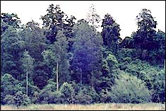
Walks After a day in the car you may like to spend some time walking. Geraldine is well sited for short walks. It was built between the Waihi River and Talbot Forest which covers the hillside behind the town.
Historic Town Trail Geraldine was first surveyed by Samuel Hewlings in 1861. He planted a totara tree to mark the birth of his first child and this tree still stands in Talbot Street.
That is one of the sites shown in a brochure which leads you on a one-hour Historic Town Trail which takes you past features as varied as old buildings, the Geraldine Domain, the old Post Office, the museum and the old Crown Hotel, and along the path by the river.
The Downs If you are feeling energetic you can add another one and a half hours to your walk and explore the Downs. I strongly recommend that you go there, either on foot or by car as the view from there gives a panorama of Canterbury mountains. The Geraldine Walks pamphlet sets out the mountains that are visible. To the north you can view Mt Peel (1717m) and further north Mt Somers (1687m) and Mt Hutt (2188m) – mountains you viewed on your journey on Highway 72. To the north-east on a clear day you can see the hills of Banks Peninsula. To the west is the Four Peaks Range.
If you walk up through Talbot Forest you will be in native forest with fine totara, matai and kahikatea and you will hear the calls of native birds, especially the trilling song of the grey warbler. If you hear noisy bird in flight be sure that it is the native pigeon, a large bird with white plumage on its breast and richly coloured wings. Because it flew slowly, it was easily caught for its flesh and its feathers before native birds were protected by law.
Trips by car Picnicking The Gorges If your plan is to find a pleasant picnic place visit one of the gorges. At Waihi Gorge (11km-7 miles) there is a spacious picnic area. Te Moana Gorge (18km-11 miles) has an extensive picnic area beside the river which at this point is usually shallow and gentle enough to provide excellent water play for children.
At Orari Gorge (15km-9miles), although it is not the steep gorge you might expect, there is a pleasant loop walk through kanuka forest with a grassy area and lookout at the top. When we walked in this area we were just leaving the grassy patch to walk down when we encountered a flock of fantails fluttering to and fro across the path in a kind of war dance defending their territory.
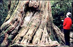
Peel Forest Te Wanahu Flat has a large and pleasant picnic area. There are several short walks which start from here. Big Tree Walk, a circuit to view large
totara trees, takes half an hour.
|
|
| The Bush at Te Wanahu Flat |
Other tracks offer longer walks including Fern Walk (2-3 hours) which, as its name suggests, takes you through many species of ferns.
Following signs on Blandswood Road you reach the Dennistoun Bush Walk (I hour) which takes you through large kahikatea and matai and to a massive totara. Some of the trees on this walk may be up to 1000 years old. On a side trip there is also a historic saw-pit with information on this method of work.
|
|
| The large totara |
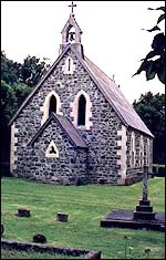
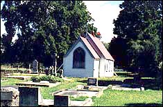
History St Stephen’s Church, Peel Forest
|
|
| St Stephen’s Church, Peel Forest, with its separate bell tower and the fish memorial. |
As you drive through the village of Peel Forest you may like to look at St Stephen’s church which has an interesting history. The first church was dashed to pieces by a whirlwind and a second was built in 1885. The bell tower of this church was blown down in 1914, possibly because the bell was too heavy for it. There is now a separate bell tower beside the church. The stained glass windows are of special interest as one shows Mitre Peak in Milford Sound and on another New Zealand native foliage and native birds are the setting for St Francis. The fish in the church grounds was carved by Paul Deans as a memorial to author Robert Finney and his wife Anne, both loyal parishioners.
Mount Peel Mount Peel station was established by John Acland and Charles Tripp in 1856, but was divided between the two owners in 1861 into Mount Peel and Orari Gorge stations. The Acland family still run Mount Peel as a successful high country farm and live in the eighteen-room ancestral homestead built in 1865.
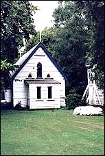
The Church of the Holy Innocents at Mount Peel
|
|
| The Church of the Holy Innocents at Mount Peel |
If you are interested in local history don’t fail to visit The Church of the Holy Innocents at Mount Peel. The name was appropriate as the church was built on the hillside which was the site of the graves of four young children who died in infancy between 1864 and 1869. The builders used greywacke from the Rangitata River and limestone brought from Mount Somers and shaped the rocks by hand. The church was consecrated by Bishop Harper on 12 December, 1869. Each year a member of the Acland family tolls the church bell to mark the beginning of a new year.
St Anne’s Church, Pleasant Valley For another exploration into history visit St. Anne’s Church at Pleasant Valley – the oldest church in South Canterbury still in use. It was built in 1863, the second church in South Canterbury, but is the oldest in use on its orginal site. The first church, St Mary’s Timaru, was built in wood and has been replaced by a stone building.
When the church was built Pleasant Valley was a busy forestry area, more prosperous than Geraldine. A landowner gave the land, men of all denominations gave their time and used their horses, bullocks, drays and tools to help with the building and the builder and the carpenter donated their time. The building was used by various denominations for their services.
|
|
| St Anne’s Church, Pleasant Valley |
By the mid 1880s when the supply of native timber was exhausted the valley became a farming district with a small population and over the years local families worked hard to maintain the church. By the 1960s the diocese declared the building to be beyond reconstruction.
However another community project secured the restoration of St Anne’s when, before it reached its centenary, with help from the National Historic Places Trust, the whole Geraldine parish joined to carry out repairs to ensure the church’s preservation.
Barrhill In the Geraldine Information Centre we were given information about another place of historical interest, Barrhill. This is an hour’s drive north-east of Geraldine. It is about 17km inland from Rakaia near the Rakaia River. We found it worth the journey, but incorporated it into our return trip to Christchurch.
At Barrhill there is another country church which with the school and schoolhouse is the only reminder of a thriving community and a man’s dream of a model settlement.
This man was John Wason, a Scotsman, who purchased land beside the Rakaia River and on a cliff beside the river built a huge mansion with a lodge and gate-keeper at the gate.
Wason wanted to develop at Barrhill a large estate with the Squire in the great house and the workers and their families in a nearby village. He was passionate about tree planting. He planned to have an avenue of oaks on the west, of birches on the east, and of sycamores and poplars on the other boundaries of the village. It was built around the Market Square. Fifteen cottages were built, and a bakery, blacksmith’s, Post Office, boiling-down works, store and village inn. These have all gone, but the Church of St John the Evangelist, remains in use.
Wason’s dream was not to come to lasting fruition as the railway which was expected to run near Barrhill ran instead further south. From a population of fifty people around 1900 the numbers grew steadily fewer until the school was closed in 1938. Wason was active in local body politics and a member of Parliament, but once he knew that the railway was not to come to Barrhill he sold his land and in 1900 returned to Britain.
The significance of some of Wason’s planning was commented on nearly a century later. From an aerial photograph it was noticed that the trees are in three circles symbolising the Trinity and the cross roads through Market Square form the shape of a cross.
Fishing If you are keen on fishing you will probably not drive far from Geraldine, but will spend your day fishing in one of the rivers close to the town.
At the end of the day if you are travelling south to Queenstown and Fiordland plan for an early start the next morning as a beautiful day’s travelling lies ahead.
Next week read about the journey to the Mackenzie country and the Southern Lakes.