Dorothy – 11/2/00
Heading towards the Mackenzie Country and the southern lakes always gives me a sense of excitement and a lift of the spirits. We are heading into some of the most beautiful country in the world. Most of us are limited in the time we can spend on holiday so it’s a matter of choices from the rich abundance of scenic delights that are available on this road.
Geraldine to Fairlie – 46km (29 miles) The road winds gently between these two country towns and gives pleasant views of undulating farm land and foothills. Eight kilometres (5 miles) before you reach Fairlie you may want to stop at The Farm Barn on Mt Michael, the highest point in the Fairlie Basin, to have a meal or a cuppa, look at the pure wool products on sale, and enjoy the panoramic view of the Fairlie area and the beckoning foothills.
Fairlie Fairlie is a peaceful thriving country town – the gateway to the Mackenzie Country – but it is much more than a gateway, it is a country town with its own identity and purpose. The Beautifying Association has been hard at work beautifying the town centre with paving and plantings and developing McLean Park where you could stop for a picnic under the beautiful trees. To reach it turn left as you reach Fairlie and you will find it opposite the golf course.
For a coffee break or a meal you have a wide choice, ranging from health foods and home made soup at The Sunflower Centre to delicious full meals at Rimuwhare. Old buildings have been put to new uses and The Old Library Cafe offers cordon bleu meals and fine coffee. A short distance on your way out of Fairlie you’ll find The Woolshed, a historic building, where you can have a tea or coffee break or lunch, see a wide range of woollen products, especially jerseys, and watch a sheep being shorn.
For information on the area go to the Resource Centre. If you ring in advance they will arrange for you to be shown around the museum which features agricultural machinery and the history of the Fairlie Flyer, a vintage train which runs from nearby Pleasant Point.
Fairlie to Tekapo – 42kms (26 miles) Easy travelling through Burke Pass takes you into the Mackenzie Country. Burke is the official discoverer of the pass in 1855 and he is remembered for his love of trees. When settlements along the foothills were being developed around the tree felling industry and farmers were burning off bush to develop pasture Burke was recommending the planting of trees and pine plantations are grown over the pass.
Mackenzie was a shepherd from the Scottish Highlands who arrived in New Zealand in the mid-1840s and explored the area that bears his name. He applied for a licence to occupy the area, but had no funds to stock it. He was caught sheep stealing, and moved away to Lyttelton where he was later arrested and imprisoned. After escaping and being recaptured three times he was allowed his freedom on condition that he left New Zealand.
The country you enter on the far side of Burke Pass doesn’t look like good farmland, but provided the rabbits are under control Merino sheep do well in this seemingly barren unpopulated land. Some six years ago I recall the earth looking totally bare without a blade of grass. Since the advent of the rabbit calicivirus the country has begun to look green in the spring and the prospects for the farmers have greatly improved.
If you are travelling in summer lupins will be in bloom along the roadside.
It is well worth pausing at the rest area as you approach Lake Tekapo to enjoy the view and take photographs.
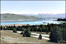 |
| View from the rest area above Lake Tekapo |
Lake Tekapo Drive down the hill to the village of Tekapo where there are all facilities needed for the tourist – accommodation, restaurants and shops.
The lake extends north for nearly 20km (12.5 miles) from the controlled outlet at the bridge. (This is an area of extensive hydro electric development.) With trout fishing and skiing visitors are attracted to a stay in Tekapo in both summer and winter. It is possible to arrange a visit to the Tekapo power station or the observatory on Mount John.
There are a number of interesting walks outlined in the free pamphlet put out by the Lake Tekapo Promotion Association. This gives a clear map of the area and details of walks ranging in length and difficulty from a short and level walk around the lake shore to the climb to Mt John Lookout which takes up to three hours.
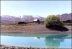 |
| The Church of the Good Shepherd Click here for a larger version |
If you don’t have time to stay here do visit the Church of the Good Shepherd built in memory of the pioneer runholders of the Mackenzie area,
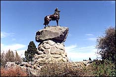 |
| The Mackenzie sheepdog |
and the bronze sheepdog sculpted in memory of the sheepdogs of the Mackenzie shepherds.
Lake Tekapo to Lake Pukaki – 47km (29 miles) – and Mount Cook – 55km (34 miles)
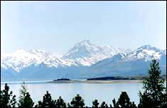 |
| Mount Cook viewed from Lake Pukaki Click here for a larger version |
On the road again you travel through tussocky country and if the skies are clear catch a glimpse of Mount Cook (New Zealand’s highest mountain) before reaching Lake Pukaki where if you are lucky with the weather you will have a clear view of the snow-capped mountain at the end of the Lake.
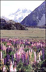 |
| Mount Cook viewed from a lupin patch near the village. Click here for a larger version |
If the view of the mountain is clear you will want to take the road to the right and travel along the western side of Lake Pukaki to Mount Cook Village. The views as you travel and from the village area are magnificent, but you may choose also to take a flight over the mountains and land on the Tasman Glacier.
If the area is shrouded in cloud and you plan to travel back by the same route you may well decide to visit Mount Cook on your return journey.
Read Part 2 of this article for more information about travelling from Lake Pukaki to Te Anau.

